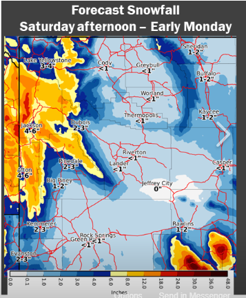
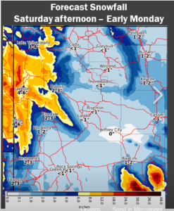
Snow Returns to Western Wyoming
A plume of moisture with origins west and south of Hawaii(atmospheric river) is aimed at Western Wyoming as can be seen in the following two images:
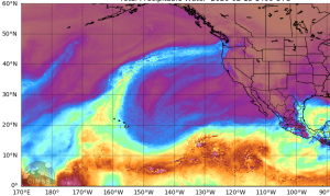
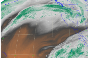
This plume will lead to a period of moderate to heavy snows in much of Western Wyoming as it translate east across the state.
The following advisories are in effect:
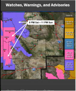
URGENT - WINTER WEATHER MESSAGE
National Weather Service Riverton WY
343 AM MST Sat Feb 15 2020

...More Snow for Western Wyoming Tonight through Sunday Night...

.A storm system will bring significant snow across much of western
Wyoming tonight through Sunday night.


Star Valley-Salt River and Wyoming Ranges-
Including the cities of Afton, Alpine, Star Valley Ranch,
and Thayne
343 AM MST Sat Feb 15 2020

...WINTER STORM WARNING IN EFFECT FROM 8 PM THIS EVENING TO 11 PM
MST SUNDAY...

* WHAT and WHERE...Moderate to Heavy snow expected. Total snow
  accumulations of 5 to 8 inches in the Star Valley, locally
  higher amounts around Alpine. Snowfall in the mountains will
  range from 10 to 18 inches.

* WHEN...From 8 PM this evening to 11 PM MST Sunday.

* IMPACTS...Travel could be very difficult. Patchy blowing snow
  could significantly reduce visibility.

* ADDITIONAL DETAILS...Please monitor the Bridger-Teton Avalanche
  Center at JHAVALANCHE.ORG, if your plans include travel into the
  back country.

PRECAUTIONARY/PREPAREDNESS ACTIONS...

If you must travel, keep an extra flashlight, food, and water in
your vehicle in case of an emergency.

The latest road conditions for the state you are calling from can
be obtained by calling 5 1 1.