Extreme Wind Event Central Rockies June 6 2020
A powerful line of thunderstorms developed Saturday morning over Eastern Utah and Western Colorado and raced northeastward across the Central Rockies into the adjacent high plains. This line of storms was driven by a strong upper low and associated jet streak that tracked from off the coast of Southern California Friday night to the Canadian border region of North Dakota Sunday morning.
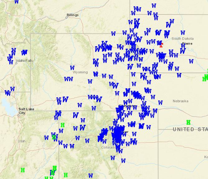
There were hundreds of reports of severe wind gusts with the storms noted in the following storm plot for Saturday June 6th.
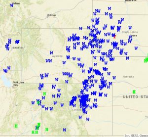
Following is a plot of observed wind exceeding 70 MPH across Colorado into Southern Wyoming.
The highest reported wind was 110 mph on top of the Winter Park Ski area in Colorado!
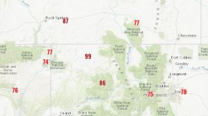
Following is a list of peak wind gusts in Wyoming
National Weather Service Riverton WY
1001 PM MDT Sat Jun 6 2020

...HIGHEST WIND REPORTS...

Location                     Speed     Time/Date     Elevation
                                                       (ft.)

Point of Rocks 10.4 E (WYDOT 87 MPH    0212 PM 06/06   7132
Atlantic City 10 NE (WYDOT)  81 MPH    0726 PM 06/06   6581
Buffalo 18 NW                79 MPH    0347 AM 06/06   8604
I25 Us87 - Tisdale Divide    76 MPH    0427 PM 06/06   4990
Ucross 28 SE (WYDOT)         75 MPH    0456 PM 06/06   4605
Echeta 20 SW (WYDOT)         73 MPH    0456 PM 06/06   4021
Meeteetse 10 S               72 MPH    1042 PM 06/05   7126
Casper Airport               70 MPH    0350 PM 06/06   5327
Rock Springs Airport         68 MPH    0208 PM 06/06   6745
Hiland 16 S                  68 MPH    0410 PM 06/06   6379
Rock Springs 15 SE           67 MPH    0244 PM 06/06   7549
I25 Us87 - Smokey Gap        66 MPH    0422 PM 06/06   5161
Shoshoni                     65 MPH    0346 PM 06/06   4822
Big Trails 15 SSW            65 MPH    0840 PM 06/05   6554
Casper                       62 MPH    0348 PM 06/06   5341
Buffalo Airport              62 MPH    0421 AM 06/06   4905
I25 - Hat Six                62 MPH    0116 AM 06/06   5157
Lander Airport               61 MPH    0603 PM 06/06   5565
Casper 2.1 SW (WYDOT)        61 MPH    0926 PM 06/06   5462
Casper 8 S                   60 MPH    0752 PM 06/06   7740
Wamsutter 10.5 E (WYDOT)     60 MPH    1112 PM 06/05   7132
Riverton Airport             59 MPH    0125 AM 06/06   5509
Beaver Rim (WYDOT)           58 MPH    0312 PM 06/06   6745
Alcova 7 W (WYDOT)           58 MPH    0332 PM 06/06   6345
Wamsutter 10 E (UPR)         58 MPH    1110 PM 06/05   7062
Red Desert 9 W (WYDOT)       58 MPH    1116 PM 06/05   6958
Hiland 2.4 SE (WYDOT)        57 MPH    1206 PM 06/06   6115
Natrona (WYDOT)              57 MPH    0346 PM 06/06   5594
South Pass City 8 W          56 MPH    1250 AM 06/06   8120
Hudson 3 NNW                 56 MPH    0146 AM 06/06   5555
South Pass                   55 MPH    0310 PM 06/06   8583
Greybull 30 E                55 MPH    1158 PM 06/05   8897
Barnum 7 SW                  55 MPH    0446 PM 06/06   6439
Mills 2 NE (WYDOT)           55 MPH    0356 PM 06/06   5312
Buffalo                      54 MPH    0500 PM 06/06   4370
Bar Nunn                     54 MPH    0359 PM 06/06   5275
Worland Airport              53 MPH    0224 AM 06/06   4190
Muddy Gap 7 SW               52 MPH    0850 PM 06/06   7379
Kaycee                       52 MPH    0430 PM 06/06   4681
Story 6 SE (WYDOT)           52 MPH    0456 PM 06/06   4783
Hyattville 5 ENE             51 MPH    0452 PM 06/06   5669
Fort Washakie 10 W           51 MPH    0201 AM 06/06   9234
Reliance 5.2 SE (WYDOT)      51 MPH    0226 PM 06/06   6345
Thayne                       50 MPH    0945 AM 06/06   5948
Bar Nunn 13.6 N (WYDOT)      50 MPH    0706 PM 06/06   5656
Crowheart                    49 MPH    0130 AM 06/06   6099
Big Piney Airport            49 MPH    0326 PM 06/06   6944
Green River 1.2 NE (WYDOT)   49 MPH    1126 PM 06/05   6325
Worland 10 SSE               49 MPH    0217 AM 06/06   4520
Crandall                     48 MPH    0912 PM 06/06   6640
Greybull Airport             48 MPH    0325 AM 06/06   3917
Reliance 8 E (UPR)           48 MPH    0205 PM 06/06   6338
Story 5.5 SE (WYDOT)         47 MPH    0456 PM 06/06   4632
Kirby                        47 MPH    0215 AM 06/06   4350
Pavillion                    47 MPH    1000 PM 06/05   5485
Star Valley Ranch            46 MPH    0930 AM 06/06   6217
Mckinnon                     46 MPH    1045 PM 06/05   7086
Snow King (BTAVAL)           46 MPH    0530 PM 06/06   7808
Point of Rocks 1.1 W (WYDOT) 46 MPH    0212 PM 06/06   6525
Lander 7 NW                  45 MPH    0616 PM 06/06   5797
Hot Springs County Airport   45 MPH    1015 PM 06/05   4901
South Pass City 2 W (WYDOT)  45 MPH    1122 AM 06/06   8195
Alcova 14.5 W (WACNET)       45 MPH    0100 AM 06/06   5903
Superior 6 SE (WYDOT)        45 MPH    0222 PM 06/06   6496

The following animation of the water vapor imagery from the GOES West satellite shows
the upper low moving northeastward from off the Southern California coast.
The Animation of the 500 mb charts shows the very rapid movement of the upper low off the Southern California coast
Of particular interest are the following animations. First is the visible imagery showing the pronounced comma configuration of the clouds as the thunderstorms organized rapidly in eastern Utah. Then the lightning as detected on the GOES West Satellite on the infrared imagery is quite impressive.