Big Snows Ahead
The long advertised pattern change is imminent. The cold air that spread across Star Valley Monday will be replaced by a strong flow of moisture that originates from the Pacific. Snow will begin Tuesday night and pick up in intensity Wednesday. While the temperatures will be rising to near or slightly above freezing by Thursday, the precipitation is expected to remain snow with heavy accumulations now forecast.
By Thursday night accumulations on the valley floor could exceed a foot with upwards of two feet in the nearby mountains, including the Salt and Wyoming Ranges The Tetons could see even greater totals of 3-4 feet.
Systems will be moving rapidly across the area in the very strong Polar Jet making it difficult to time the periods of increased snowfall rates after Thursday. However, snow will continue to fall through the coming weekend with additional significant amounts likely.
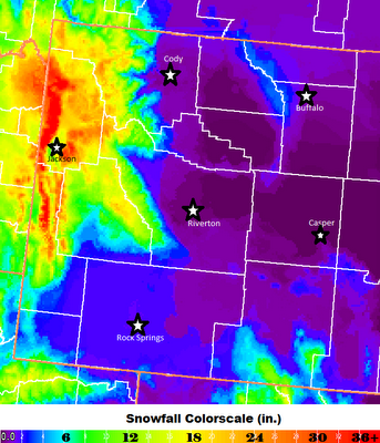
Below is a graphic with the forecast of snowfall totals by Friday morning.
 |
| Snowfall Totals Forecast by Friday Morning 01/20/12 |
There will be a sharp drop off in snowfall in the downslope areas of Central Wyoming where very strong winds will be the greater risk.