Roller Coaster Daily Temperature Ranges
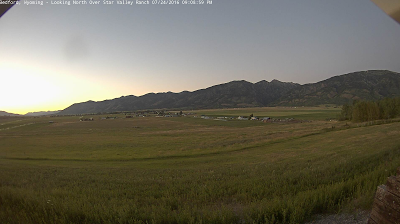
Western Wyoming is currently under a classic regime of clear skies, low humidity and calm nighttime winds that produce dramatic diurnal temperatures ranges. Following is a view of Star Valley at sunset Sunday with another cool night ahead.
 |
| Bedford Cam Sunday evening.
Double L weather station along the Salt River is typical of large temperature ranges in many Star Valley areas the past several days.

While each afternoon has seen temperatures rise into the 80’s the nights cool off dramatically. Just this Sunday morning the low was 33, with likely some light frost in sheltered area, while this afternoon once again it warmed to 83, some 51 degrees above the morning minimum
Even more dramatic is the 7 day graph at Bondurant.

The last couple of mornings have seen lows below freezing, followed by 80’s by late afternoon . Just this Sunday after a frigid morning low of 25, the temperature rose 58 degrees to an afternoon high of 83.
However in the mountains, the nighttime inversion does not develop to the extent as in the nearby valleys. Such an example is on Deadman Peak, elevation above 10,000 feet.

Diurnal changes in the mountains are considerably less than the nearby valleys. In this case only 20 degrees or so.
In the Tetons, at Teton Saddle, variations from night to day are even less at the 11,600 feet elevation.

At that elevation while the days are cooler than nearby valley areas, the nights are mild with only 10-15 degree ranges.
|