 |
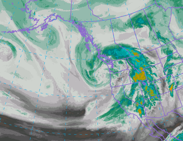
| Water Vapor Imagery Friday Morning April 7 2017
|
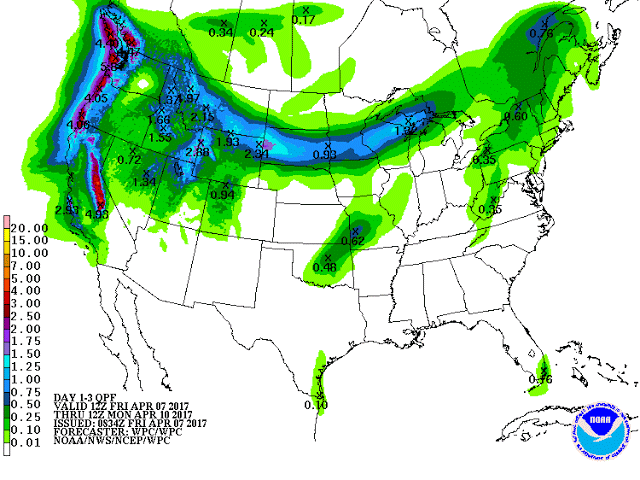 |
| Forecast Precipitation Through Monday Morning |
URGENT - WINTER WEATHER MESSAGE
National Weather Service Pocatello ID
208 AM MDT Fri Apr 7 2017


Caribou Highlands-Wasatch Mountains/Idaho Portion-
Including the cities of Henry, Soda Springs, Downey,
Lava Hot Springs, and Montpelier
208 AM MDT Fri Apr 7 2017

...WINTER WEATHER ADVISORY IN EFFECT FROM 6 PM THIS EVENING TO
6 AM MDT SUNDAY...

The National Weather Service in Pocatello has issued a Winter
Weather Advisory for snow, which is in effect from 6 PM this
evening to 6 AM MDT Sunday.

* IMPACTS...Roads may become slushy, snow covered and slick.

* TIMING...Rain or a mix of rain and snow should quickly change
  over to snow after sunset tonight. Heavy snow is possible at
  times this evening. A break in activity is expected Saturday
  morning with heavier snow showers re-developing late Saturday
  afternoon through Saturday night.

* SNOW ACCUMULATIONS...1 to 3 inches valleys. 4 to 7 inches for
  mountain passes.

* CONFIDENCE...Timing: medium to high. Amounts: medium to high.

* LOCATIONS...Soda Springs, Grace, Montpelier, Emigration Pass,
  Fish Creek Pass, Border Summit, Geneva Summit.

PRECAUTIONARY/PREPAREDNESS ACTIONS...

A winter weather advisory for snow means that periods of snow
will cause primarily travel difficulties. Be prepared for snow
covered roads and limited visibilities, and use caution while
driving.
...From Riverton Forecast Office...
...WINTER STORM WATCH FOR THE WESTERN AND SOUTHWESTERN MOUNTAINS
OF WYOMING BEGINNING TONIGHT AND CONTINUING THROUGH SATURDAY
NIGHT...

This Hazardous Weather Outlook is for Western and Central Wyoming.

.DAY ONE...Today and Tonight

Warming temperatures and increasing southwest wind will result in
accelerated melting of snowpack below 9000 feet with significant
rises in some rivers and creeks beginning today.

A moderate to strong wind will blow from Rocks Springs
to Casper. The mountains and eastern slope foothills, including
Lander will also have the potential for strong winds at times.

The first of a couple of upper level disturbances and associated
cold fronts will bring significant rain, snowfall and wind to the
western mountains beginning tonight. Western valleys will likely
see mainly rain showers until well after midnight when a
changeover to a rain snow mix or all snow is possible before sun
up.

.DAYS TWO THROUGH SEVEN...Saturday through Thursday

Saturday through Sunday...A couple of upper level disturbances
and associated fronts will bring significant rain, snowfall and
wind to the western mountains beginning Friday night and lasting
periodically through Sunday. Heavier western valley snow will be
possible Saturday night...with some areas east of the divide
seeing snowfall on Sunday, mainly over and near the Bighorn
mountains.


