Snow, Rain and Wind Reports for Saturday April 8th Storm
 |
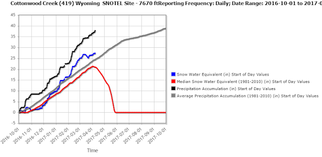
| And the Snow Pack Continues to Increase in Nearby Mountains |
Public Information Statement National Weather Service Riverton WY 600 PM MST Sat Apr 08 2017 ...Preliminary Storm Information... The following are storm reports for snowfall, precipitation, and peak winds for the 24 hour period from 6 pm Friday , April 7th until 6 pm on Saturday, April 8th. Observations are collected from a variety of sources with varying equipment and exposures. Not all data listed are considered official. SnoTELs (Snow Telemetry) are remote sensing sites in high mountain watersheds. Snowfall data from SNOTELS are estimated based on snow water equivalent. ***** 24 Hour Snowfall Reports ***** Location SnowfallLincoln County... Willow Creek Snotel... 13 inches. Cottonwood Creek Snotel... 12 inches. Blind Bull Summit Snotel... 11 inches. 5 SSE Smoot... 11 inches. Salt River Summit Snotel... 9 inches. 3 SE Bedford... 8.5 inches. Afton... 8.3 inches. Spring Creek Divide Snotel... 8 inches. Star Valley Ranch... 8 inches. 2 SE Thayne... 7 inches. Star Valley Ranch... 6.5 inches. Blind Bull Summit... 6 inches. Commissary Ridge... 5 inches. Box Y Ranch... 5 inches. Indian Creek Snotel... 5 inches. Kelley Ranger Station Snotel... 3 inches.Big Horn County...
Bald Mountain Snotel... 2 inches.
Shell Creek Snotel... 1 inch.Fremont County...
Little Warm Snotel... 7 inches.
Brooks Lake... 6 inches.
Cold Springs Snotel... 4 inches.
Deer Park Snotel... 4 inches.
Hobbs Park Snotel... 3 inches.
South Pass Snotel... 2 inches.
Dubois... 1 inch.Johnson County...
Bear Trap Meadow Snotel... 3 inches.
Hansen Sawmill Snotel... 1 inch.Natrona County...
Grave Spring Snotel... 2 inches.Park County...
Evening Star Snotel... 3 inches.
Blackwater Snotel... 3 inches.
Younts Peak Snotel... 2 inches.
Kirwin Snotel... 1 inch.
Pahaska... 0.2 inches.Sublette County...
Triple Peak Snotel... 13 inches.
Gunsite Pass Snotel... 11 inches.
Loomis Park Snotel... 5 inches.
New Fork Lake Snotel... 5 inches.
Elkhart Park G.S. Snotel... 5 inches.
Snider Basin Snotel... 5 inches.
14 NW Pinedale... 4.3 inches.
East Rim Divide Snotel... 4 inches.
Daniel Fish Hatchery... 3 inches.
Pinedale... 2.8 inches.
13 NE Big Piney... 2.5 inches.
Kendall Ranger Station Snotel... 2 inches.Teton County...
Grand Targhee - Chief Joseph... 8 inches.
Jackson Hole - Rendezvous Bowl... 8 inches.
Togwotee Pass Snotel... 7 inches.
Jackson Hole - Mid Mountain... 6 inches.
Togwotee Mountain Lodge... 6 inches.
Jackson Hole - Raymer... 5 inches.
Grassy Lake Snotel... 4 inches.
Phillips Bench Snotel... 4 inches.
3 SSW Wilson... 2.5 inches.
Granite Creek Snotel... 2 inches.
Jackson Hole - Base... 2 inches.
Jackson Dam... 1.1 inches.
Base Camp Snotel... 1 inch.
12 NE Jackson... 1 inch.
Moose... 0.4 inches.Washakie County...
Powder River Pass Snotel... 2 inches.Yellowstone National Park...
Lewis Lake Divide Snotel... 6 inches.
Canyon Snotel... 3 inches.
Thumb Divide Snotel... 2 inches.
Parker Peak Snotel... 2 inches.
Sylvan Lake Snotel... 2 inches.***** 24 Hour Precipitation Reports *****
Location Amount Time/Date Elevation (ft.)
...Star Valley... Bedford - Coop 1.48 in 0700 AM 04/08 6425 3 NW Etna 1.34 in 0430 PM 04/08 5676 Star Valley Ranch 1.20 in 1000 AM 04/08 6253 Afton - Coop 1.16 in 0800 AM 04/08 6245 5 SSE Smoot 1.14 in 0700 AM 04/08 7005 1 NW Afton 1.13 in 0400 PM 04/08 6211 Afton 1.07 in 0439 PM 04/08 6267 2 SE Thayne 0.98 in 0700 AM 04/08 6086 3 NW Etna 0.91 in 0451 PM 04/08 5692 Etna 0.90 in 0452 PM 04/08 5823 1 S Bedford 0.88 in 0444 PM 04/08 6279 5 NNE Thayne 0.88 in 0700 AM 04/08 6377 3 N Etna 0.58 in 0700 AM 04/08 Thayne 0.49 in 0442 PM 04/08 5928 4 NE Thayne 0.47 in 0440 PM 04/08 6217...Yellowstone National Park...
4 W South Entrance Ynp 0.45 in 0445 PM 04/08 7040
1 SW Canyon 0.43 in 0449 PM 04/08 7900
South Entrance Ynp 0.41 in 0445 PM 04/08 6900
Mammoth 0.29 in 0415 PM 04/08 6300
Lake Village 0.28 in 0400 PM 04/08 7875
Lake Yellowstone 0.26 in 0556 AM 04/08 7835
15 WSW Mammoth 0.24 in 0449 PM 04/08 7900
14 S Sylvan Pass 0.20 in 0408 PM 04/08 8650
Gardner River Nr Mammoth 0.16 in 0445 PM 04/08 5624...Wind River Mountains West...
19 WSW Dubois 0.49 in 0410 PM 04/08 8833
7 NE Pinedale 0.19 in 0426 PM 04/08 8530...Wind River Mountains East...
10 W Dubois 0.28 in 0453 PM 04/08 8432
9 SW Lander 0.19 in 0400 PM 04/08 7085
10 W Fort Washakie 0.17 in 0401 PM 04/08 9235...Wind River Basin...
N. Fork Little Wind River 0.13 in 0445 PM 04/08 6120...Upper Wind River Basin...
Dubois 0.35 in 0600 AM 04/08 6955
6 NW Dubois 0.32 in 0415 PM 04/08 7189
11 W Crowheart 0.16 in 0445 PM 04/08 6520...Upper Green River Basin...
5 SSE La Barge 0.27 in 0400 PM 04/08 6530
13 NE Big Piney 0.15 in 1000 AM 04/08 6946...Upper Green River Basin Foothills...
Bondurant 0.40 in 0400 PM 04/08 6650
2 NW Bondurant 0.38 in 0451 PM 04/08 6726
Daniel Fish Hatchery - Coop 0.33 in 0800 AM 04/08 7335
10 NNW Daniel 0.24 in 0330 PM 04/08 7470
14 NW Pinedale 0.20 in 0650 AM 04/08 7469
Pinedale 0.19 in 0400 PM 04/08 7310...Teton and Gros Ventre Mountains...
17 N Alta 0.50 in 0403 PM 04/08 6830
Alta 0.43 in 0445 PM 04/08 6430...Southeast Johnson County...
2 NW Mayoworth 0.21 in 0450 PM 04/08 5404...Southeast Big Horn Basin...
10 SSE Worland 0.12 in 0417 PM 04/08 4520...South Lincoln County...
Cokeville 0.36 in 0448 PM 04/08 6191
Kemmerer 0.15 in 0400 PM 04/08 6980...Salt River and Wyoming Ranges...
Smiths Fork Near Border 0.45 in 0430 PM 04/08 6650
21 W Big Piney 0.41 in 0409 PM 04/08 8200
15 NE Cokeville 0.35 in 0400 PM 04/08 8470
13 E Cokeville 0.21 in 0330 PM 04/08 7460...Rock Springs and Green River...
Green River 0.14 in 0430 PM 04/08 6060
Mckinnon 0.11 in 0440 PM 04/08 7086...Northeast Johnson County...
13 SSE Buffalo 0.21 in 0200 PM 04/08
7 NE Buffalo 0.14 in 0446 PM 04/08 4370...Lander Foothills...
Middle Fork Popo Agie River 0.18 in 0415 PM 04/08 6555
11 SSE Lander 0.16 in 0400 PM 04/08 5773...Jackson Hole...
3 SSW Wilson 0.64 in 0800 AM 04/08 7010
2 NE Wilson 0.50 in 0451 PM 04/08 6184
12 NE Jackson 0.44 in 0700 AM 04/08 6653
4 N Moose 0.43 in 0358 PM 04/08 6730
5 S Of South Entrance Ynp 0.42 in 0345 PM 04/08 7020
Jackson 0.38 in 0445 PM 04/08 6240
Moose - Coop 0.36 in 0900 AM 04/08 6445
12 NE Jackson 0.36 in 0800 AM 04/08 6663
7 E Moran Jct 0.35 in 0452 PM 04/08 7251
Jackson 0.33 in 0445 PM 04/08 6247
Kelly 0.32 in 0441 PM 04/08 6653
5 NW Jackson 0.32 in 0900 AM 04/08 6217
Snake River At Jackson Lake 0.29 in 0445 PM 04/08 6779
Moran 0.29 in 0800 AM 04/08 6800
Jackson Hole Airport 0.18 in 0555 AM 04/08 6445
Hoback Junction 0.11 in 0459 PM 04/08 5928...Flaming Gorge...
3 NE Manila Ut 0.12 in 0415 PM 04/08 6060...Bighorn Mountains West...
15 SSW Big Trails 0.32 in 0440 PM 04/08 6554
12 ENE Ten Sleep 0.12 in 0414 PM 04/08 8202
30 E Greybull 0.11 in 0358 PM 04/08 8898...Bighorn Mountains Southeast...
7 NW Mayoworth 0.34 in 0400 PM 04/08 5720
14 W Buffalo 0.21 in 0415 PM 04/08 8400
16 SE Big Trails 0.15 in 0400 PM 04/08 7220
18 NW Buffalo 0.14 in 0447 PM 04/08 8604
20 NW Mayoworth 0.12 in 0400 PM 04/08 8180
7 SW Barnum 0.11 in 0446 PM 04/08 6440...Absaroka Mountains...
Pahaska 0.35 in 0700 AM 04/08 6696
3 E Pahaska 0.19 in 0357 PM 04/08 7500
NE Entrance Yellowstone 0.19 in 0445 PM 04/08 7360
10 N Dubois 0.11 in 0357 PM 04/08 8085***** 24 Hour Peak Wind Reports *****
Location Speed Time/Date Elevation (ft.)
...Wyoming...
...Fremont County...
Red Canyon 66 MPH 1235 AM 04/08 6768
7 SW Muddy Gap 64 MPH 1150 PM 04/07 7380
3 NNW Hudson 54 MPH 1246 AM 04/08 5555
Jeffrey City 46 MPH 1100 PM 04/07 6374
7 NW Lander 46 MPH 0716 PM 04/07 5797
10 W Fort Washakie 40 MPH 0101 AM 04/08 9235...Hot Springs County...
Boysen Peak 52 MPH 0715 PM 04/07 7300
Thermopolis 41 MPH 0606 PM 04/07 4426...Johnson County...
18 NW Buffalo 67 MPH 0747 PM 04/07 8604
25 ESE Buffalo 45 MPH 0655 PM 04/07 4657
Buffalo Airport 40 MPH 1212 AM 04/08 4970...Lincoln County...
Mt Coffin 52 MPH 0600 PM 04/07 10870
Deadman Mtn 40 MPH 0600 PM 04/07 10350...Natrona County...
16 S Hiland 57 MPH 1210 AM 04/08 6380
Casper Outer Drive 47 MPH 1226 AM 04/08 5463
20 N Casper 45 MPH 0540 PM 04/07 5677
Casper Airport 44 MPH 0124 AM 04/08 5320
2 SE Hiland 43 MPH 0605 PM 04/07 6134
7 W Alcova 43 MPH 1200 AM 04/08 6342
3 WSW Mills 42 MPH 1120 PM 04/07 5197
8 S Casper 42 MPH 0252 PM 04/08 7740...Park County...
5 WNW Clark 62 MPH 0935 PM 04/07 4659
Chief Joseph Hwy 62 MPH 0520 PM 04/07 8136
10 WNW Cody 51 MPH 0540 PM 04/07 8401
20 SW Cody 45 MPH 0524 PM 04/08 5843
Cody Airport 44 MPH 0443 PM 04/07 5100
2 WSW Cody 44 MPH 1140 PM 04/07 5167
Hoyt Peak 44 MPH 0730 PM 04/07 9800
8 S Clark 43 MPH 0900 PM 04/07 4710
1 W Clark 43 MPH 0914 PM 04/07 4270
8 N Meeteetse 42 MPH 0531 PM 04/07 5926...Sublette County...
Big Piney Airport 44 MPH 0804 PM 04/07 6974...Sweetwater County...
I 80 - Mile Marker 184 48 MPH 1021 AM 04/08 7112...Teton County...
1 W Grant Village 69 MPH 0840 PM 04/07 7874
5 ENE Alta - Freds Mtn 60 MPH 0445 PM 04/07 9840
Summit - Jackson Resort 47 MPH 0600 PM 04/07 10318...Washakie County...
10 SSE Worland 47 MPH 0517 PM 04/07 4520
Worland Airport 44 MPH 0507 PM 04/07 4245