The second and most potent storm of the week will be affecting Western Wyoming
and Star Valley beginning Wednesday night and continue into Friday. Following is
an animated water vapor imagery showing the next and more powerful system
heading from the Gulf of Alaska toward the Pacific Northwest this afternoon.
In response to the next system, Riverton Forecast Office has issued a
Winter Storm Watch for the mountains of Northwest Wyoming beginning Wednesday
Night.
National Weather Service Riverton WY
1259 PM MST Tue Nov 14 2017

...Heavy Snow in the Tetons and Gros Ventre Ranges late Wednesday
Night through Friday Morning...

.A new much more powerful storm system will impact the west
beginning later Wednesday night, continuing into Friday. Even
though the storm system is quite warm into Thursday, the mountains
will see all snow with rain or a rain and snow mixture in the western
valleys. A cold front will move in late Thursday, producing colder
temperatures and likely the heaviest period of snowfall of the
storm for Thursday night into Friday morning. The snow will be
accompanied by gusty to strong winds with areas of blowing snow,
especially as temperatures drop late Thursday into Thursday night.


Teton and Gros Ventre Mountains-
1259 PM MST Tue Nov 14 2017

...WINTER STORM WATCH IN EFFECT FROM LATE WEDNESDAY NIGHT THROUGH
FRIDAY MORNING...

* WHAT...Heavy snow possible. Travel will be very difficult to
  impossible, including during the morning commute on Thursday
  over Teton Pass. Total snow accumulations of 1 to 2 feet with
  locally higher amounts on the west side of the Tetons, are
  possible.

* WHERE...Teton and Gros Ventre Mountains.

* WHEN...From late Wednesday night through Friday morning.

* ADDITIONAL DETAILS...Significant reductions in visibility are
  possible as west to southwest winds of 20 to 40 mph blow the
  snow around.

PRECAUTIONARY/PREPAREDNESS ACTIONS...

A Winter Storm Watch means there is potential for significant
snow that may impact travel. Continue to monitor the latest
forecasts.
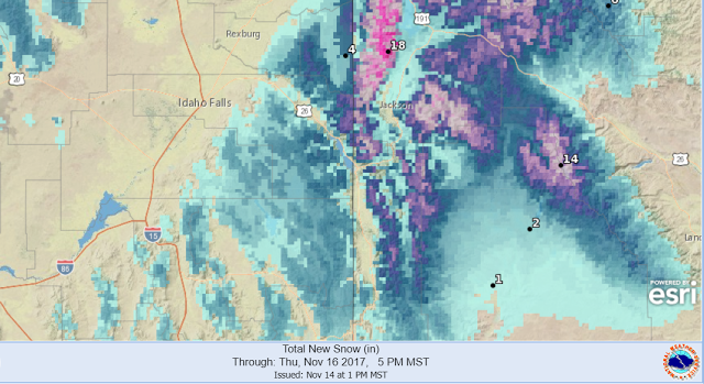
Following is the forecast snowfall up until Thursday evening as issued by the
Riverton Forecast Office.
The next graphic is the computer model forecast of total snowfall ending Friday
evening.