Cloud Seeding in Star Valley and Western Wyoming-An Update 2019
This is an update of the blog posted in December 2014 about Cloud Seeding in Star Valley, Western Wyoming and Southeast Idaho
Since our snow season is rapidly approaching and many may not have seen this blog the last time it was posted about two years ago, here it is again.
The Winter of 2019-2020 will be the 8th in which active cloud seeding will be conducted in Star Valley with the goal of enhancing the snow pack over the Salt and Wyoming Ranges. The seeding is being done by Idaho Power out of Boise ID who provides electricity across Southern Idaho and Eastern Oregon. Questions were submitted about cloud seeding to Idaho Power as it relates to Star Valley. Derek Blestrud, one of the three Idaho Power meteorologist, responded with very informative answers.
Following are those questions and answers.
1. How long has Idaho Power been conducting cloud seeding?
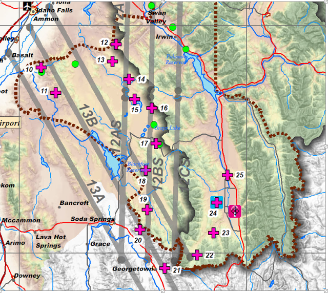
Idaho Power first started looking into cloud seeding in the early 90’s in response to a question from a shareholder. After an extensive literature and climatology study, Idaho Power first contracted a cloud seeding program in the 96-97 winter seasons in the Payette River Basin north of Boise. The project was soon suspended due to excessive snowpack. In 2003, Idaho Power began operating its own cloud seeding project in the Payette River Basin. In 2008 Idaho Power began working with the High Country RC&D and expanded operations into the Upper Snake Region. In 2006 the State of Wyoming released the results of a Level II feasibility study evaluating cloud seeding potential in the Salt and Wyoming ranges. In 2010, Idaho Power working with the Western Wyoming RC&D to build upon Wyoming’s feasibility study and began collecting weather data to further evaluate the feasibility of cloud seeding in the Salt and Wyoming Ranges of western Wyoming and began seeding in 2012.
Generators 22, 23, 24 and 25 affect the Salt and Wyoming Ranges directly
2. How much increase in snowfall has been credited to the cloud seeding?
Determining the benefits of cloud seeding have a lot of variables. They range from the spatial variations in natural snowpack to the difficulties providing uniform targeting of cloud seeding. The targeting issue is a function of cloud seeding generator spacing and elevation as well as aircraft operations and storm conditions. Nevertheless, literature shows that a well-run wintertime orographic cloud seeding program can increase precipitation by 5 to 15%. Using an analysis over the Payette target area since seeding began in 2003 has shown an 11% increase during that time frame. Using a similar approach to look at the increases in the upper Snake region, there has been an average annual increase of 7.6% for the duration of the project.
Idaho Power has continued to look for better ways to assess cloud seeding. Since 2011, Idaho Power has worked with the National Center of Atmospheric Research(NCAR) in developing a computer model to simulate the benefits of cloud seeding. This past winter, IPC expanded this effort by partnering with a number of universities(including the University of Wyoming) to collect microphysical data of both natural clouds as well as clouds that had been seeded. This project, titled Seeded and Natural Orographic Wintertime Clouds: the Idaho Experiment(SNOWIE), provided the best physical dataset of the effect of cloud seeding to date. As this data is processed, peer reviewed and ulitimately published, our understanding of the benefits from cloud seeding should be greatly improved.
3. What are the ideal conditions to determine when to begin seeding?
Cloud seeding works best when there is an abundance of supercooled liquid water(SLW) within a storm system and a lack of ice nuclei as well as a wind direction that will provide enough orographic lift to transport the seeding agent into the storm system and areas of SLW. The most common time that this occurs is when there is a warmer wintertime storm system that is very shallow(does not have the upper cold portion of the cloud to feed ice crystals into the SLW layer). Silver iodide works best for cloud seeding between the temperatures of -5 to -15°C(23 to 5F) with the sweet spot between -8 and -10°C(18 to 14F). At warmer temperatures, freezing of the SLW is just too slow to produce precipitation increases with silver iodide. At cooler temperatures, the clouds become adequate in supplying the SLW layer with ice crystals to naturally seed the cloud.
4. How much affect does seeding have on the amount of snowfall in the populated areas of Star Valley vs the adjacent mountains?
The increases in snowfall from cloud seeding in valley locations are minimal. Cloud seeding relies on the upslope flow of weather systems that are forced up and over a mountain range. Air that is rising will cool and become saturated, eventually leading to precipitation. On the downwind side, the air mass then descends and warms, and precipitation is reduced As a result of this rising and falling air mass the bulk of enhancement from cloud seeding typically falls on the upslope portion of the mountains, especially near the ridgelines(It is interesting to note that generator #25 located in the Narrows is about 5 miles west(upwind) of Turnerville, a well known snowy area of Star Valley).
5. Who are the primary benefactors of the increased snowfall/runoff?
The primary benefactors are anyone that uses or depends upon water. As a power company, our hydro projects are downstream of numerous users. We are essentially at the end of the ditch so all others that are higher in the watershed use that water before it gets to us. To better understand how that additional water benefits groups, follow it downstream. By adding additional snow pack to a watershed, that watershed becomes healthier. There is more water available for plants and animals. The additional snow on the ground also helps with recreational uses such as snowmobiling, skiing, snowshoeing, etc. The increased snowpack also supplies additional runoff that provides better habitat for fish and recreational uses along the rivers such as fishing and white water sports. This additional water is then available for farmers to irrigate crops and for other municipal uses. The water that is left over then runs through Idaho Powers Hydroelectric generation facilities to create cheap, clean and renewable energy which helps to reduce electricity costs to our consumers.
6. How many meteorologists are involved in the project?
Idaho Power is using 3 internal full time meteorologists as well as 2 contract meteorologist that will be with us through the winter..
7. Are the NWS forecast offices in the area of seeding, Pocatello, Riverton and Boise, aware of when the seeding is going to be done so they can incorporate the enhanced snowfall into their forecasts?
On occasion we have worked with the various offices to supply information to them. We have given them access to some of our operational meteorological equipment, but we do not inform them when we are seeding.
8. I understand that contract soundings are conducted on request at the Afton Airport.
How many times in the course of a winter are these soundings taken and generally what time of day?
We roughly launch between 50-75 sounding per winter season (Nov – Apr). These soundings are at all times during the day. The intent is to give us near real time upper air data to support operations. Typically we launch a sounding before, or as the storm arrives, and then every 2-6 hrs during the storm. This information helps guide operational decisions. If a storm is fairly uniform, fewer soundings are used, but if the storm is evolving rapidly, we tend to launch more.
9. How high is data collected?
For the most part, the data that we are interested in is all below 500 mb(18,000 feet). That said, we have directed our operators to collect data up to 250 mb(34,000 feet) before cancelling the flight as long as the balloon is still gaining elevation.
10. Are these soundings available to the WFO’s that forecast for the region affected? Also could they be accessed by other interested parties?
In the past we have looked at ways to share the sounding data with the forecasters at each of the National Weather Service offices. The biggest issue that we run into is that our weather balloons operate with different software than what is used in the NWS. We have not found an easy way to share the date in a suitable format that the NWS forecasters can use in a timely fashion.
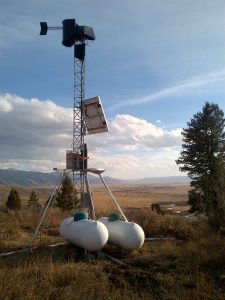
Narrows Cloud Seeding generator #25 view toward Afton
Cloud seeding generator #25 on the east side of the Narrows on the Salt River
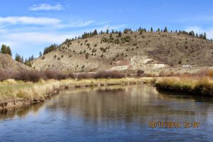
Same view of generator #25 from the Salt River near Auburn Bridge