National Weather Service Riverton WY
659 PM MST Sat Feb 23 2019
...A Series of Winter Storms will impact Western Wyoming Tonight
through Tuesday...
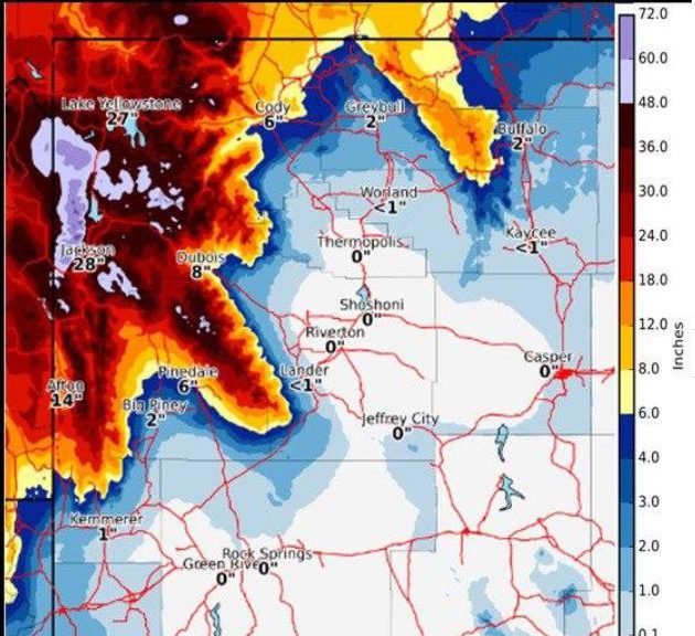
.Significant snow and blowing snow will occur across much of
western Wyoming tonight, and persist through Tuesday. This snow
will combine with gusty winds by Sunday, which will produce
blowing and drifting snow, very low visibility and bitterly cold
wind chills.
Including the cities of Afton, Alpine, Star Valley Ranch,
and Thayne
659 PM MST Sat Feb 23 2019
...WINTER STORM WARNING REMAINS IN EFFECT UNTIL 5 PM MST
TUESDAY...
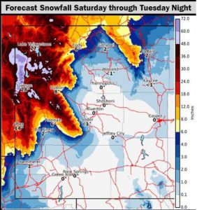
* WHAT...Heavy snow expected. Accumulations of 1 to 2 inches
expected tonight. Total snow accumulations of 12 to 18 inches
expected through the day Tuesday.
* WHERE...Star Valley.
* WHEN...Until 5 PM MST Tuesday.
* ADDITIONAL DETAILS...Travel could be difficult at times.
PRECAUTIONARY/PREPAREDNESS ACTIONS...
A Winter Storm Warning for snow means severe winter weather
conditions will make travel very hazardous or impossible. If you
must travel, keep an extra flashlight, food and water in your
vehicle in case of an emergency.
Please monitor JHAVALANCHE.ORG if your plans include travel into
the back country.
ACROSS THE STATE LINE IN SOUTHEAST IDAHO SIMILAR WEATHER IS EXPECTED
National Weather Service Pocatello ID
255 PM MST Sat Feb 23 2019


...LONG-DURATION WINTER STORM TO BRING VARYING IMPACTS ACROSS
SOUTHEAST IDAHO...

Bear River Range-Blackfoot Mountains-Caribou Range-
Big Hole Mountains-Teton Valley-Centennial Mountains -
Island Park-
Including the cities of Soda Springs, Henry, Bone, Victor,
Ashton, Driggs, and Island Park
255 PM MST Sat Feb 23 2019

...WINTER STORM WARNING REMAINS IN EFFECT FROM 6 PM THIS EVENING
TO 5 PM MST TUESDAY...

* WHAT...Periods of moderate to heavy snow and blowing snow are
  expected. Three day total snow accumulations of 2 to 3 feet.
  Locally higher amounts are possible in the mountains above pass
  level.

* WHERE...The Upper Snake Highlands, Big Hole Mountains, Teton
  Valley, the Caribou Range, the Bear River Range and Blackfoot
  Mountains including but not limited to Ashton, Island Park,
  Henry`s Lake, Raynolds Pass, Targhee Pass, Driggs, Victor, Pine
  Creek Pass, Palisades, Swan Valley, Emigration Summit, Fish
  Creek Summit, Soda Springs, Grace, and Bancroft.

* WHEN...From 6 PM this evening to 5 PM MST Tuesday.

* IMPACTS...Difficult travel conditions are expected due to snow
  covered and slippery roads and reduced visibility. Southwest
  winds of 15 to 25 MPH gusting as high as 40 MPH will cause areas
  of blowing and drifting snow and localized whiteouts, especially
  Sunday afternoon, Sunday night, and Monday.