National Weather Service Riverton WY
530 AM MDT Mon Oct 28 2019
 ...An Arctic front will bring snow and frigid temperatures to
Wyoming Monday through Tuesday...
.An arctic front will bring another round of snow, along with
bitter cold temperatures, to areas of western and central
Wyoming. Areas west of the Divide will be more impacted by snow
with this storm. Snow will begin to end from north to south, with
light snow continuing over central portions and west of the
Divide Tuesday afternoon.
Star Valley-Salt River and Wyoming Ranges-
Upper Green River Basin Foothills-
Including the cities of Afton, Alpine, Star Valley Ranch, Thayne,
and Pinedale
530 AM MDT Mon Oct 28 2019
...WINTER WEATHER ADVISORY REMAINS IN EFFECT FROM 6 PM THIS
EVENING TO 3 PM MDT TUESDAY...
...An Arctic front will bring snow and frigid temperatures to
Wyoming Monday through Tuesday...
.An arctic front will bring another round of snow, along with
bitter cold temperatures, to areas of western and central
Wyoming. Areas west of the Divide will be more impacted by snow
with this storm. Snow will begin to end from north to south, with
light snow continuing over central portions and west of the
Divide Tuesday afternoon.
Star Valley-Salt River and Wyoming Ranges-
Upper Green River Basin Foothills-
Including the cities of Afton, Alpine, Star Valley Ranch, Thayne,
and Pinedale
530 AM MDT Mon Oct 28 2019
...WINTER WEATHER ADVISORY REMAINS IN EFFECT FROM 6 PM THIS
EVENING TO 3 PM MDT TUESDAY...
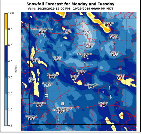
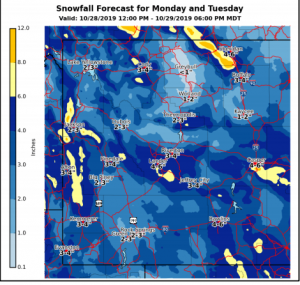
 * WHAT...Snow expected. Total snow accumulations of 3 to 4
inches in the Star Valley and near Pinedale and Bondurant. 4
to 8 inches in the mountains. Winds gusting as high as 25 mph,
increasing to 40 mph in the mountains Tuesday.
* WHERE...Star Valley, Salt River and Wyoming Ranges and Upper
Green River Basin Foothills.
* WHEN...From 6 PM Monday to 3 PM MDT Tuesday.
* WHAT...Snow expected. Total snow accumulations of 3 to 4
inches in the Star Valley and near Pinedale and Bondurant. 4
to 8 inches in the mountains. Winds gusting as high as 25 mph,
increasing to 40 mph in the mountains Tuesday.
* WHERE...Star Valley, Salt River and Wyoming Ranges and Upper
Green River Basin Foothills.
* WHEN...From 6 PM Monday to 3 PM MDT Tuesday.
 * IMPACTS...Plan on slippery road conditions. Patchy blowing
snow could significantly reduce visibility. The hazardous
conditions could impact the morning or evening commute. The
cold wind chills as low as 20 below zero could cause frostbite
on exposed skin in as little as 30 minutes.
PRECAUTIONARY/PREPAREDNESS ACTIONS...
Slow down and use caution while traveling.
* IMPACTS...Plan on slippery road conditions. Patchy blowing
snow could significantly reduce visibility. The hazardous
conditions could impact the morning or evening commute. The
cold wind chills as low as 20 below zero could cause frostbite
on exposed skin in as little as 30 minutes.
PRECAUTIONARY/PREPAREDNESS ACTIONS...
Slow down and use caution while traveling.