New Years Day Snowfall Totals
Public Information Statement
National Weather Service Riverton WY
340 PM MST Thu Jan 02 2020
…Final Snowfall Amounts for New Year`s Storm…
A winter storm impacted western Wyoming to ring in 2020. Snow began
falling New Year`s Eve and continued through New Year`s Day. The
following are final snow reports for this storm through Thursday
morning.
Note: Location of reports are referenced from city center. Snowfall
reports from SNOTEL (Snow Telemetry) sites are estimated.
Location Snowfall
Big Horn County…
Bald Mountain Snotel… 8 inches.
Bone Springs Divide Snotel… 3 inches.
9 ENE Greybull… 0.6 inches.
Fremont County…
Brooks Lake… 13 inches.
Burroughs Creek Snotel… 4 inches.
Little Warm Snotel… 2 inches.
Castle Creek Snotel… 1 inch.
Johnson County…
Buffalo… 0.2 inches.
Lincoln County…
Cottonwood Creek Snotel… 19 inches.
Commissary Ridge… 18 inches.
5 NNE Thayne… 17.5 inches.
3 SE Bedford… 13.5 inches.
Alpine… 13 inches.
1 NW Alpine… 12 inches.
Willow Creek Snotel… 12 inches.
Blind Bull Summit Snotel… 12 inches.
Box Y Ranch… 12 inches.
2 SE Thayne… 11.3 inches.
Blind Bull Summit… 10 inches.
5 SSE Smoot… 9 inches.
Indian Creek Snotel… 9 inches.
Star Valley Ranch… 7 inches.
Afton… 6.1 inches.
Kelley Ranger Station Snotel… 6 inches.
Spring Creek Divide Snotel… 6 inches.
Salt River Summit Snotel… 6 inches.
Hams Fork Snotel… 4 inches.
Kemmerer… 2 to 3 inches.
3 S Fontenelle Dam… 1 inch.
Park County…
Beartooth Lake Snotel… 11 inches.
Evening Star Snotel… 8 inches.
Wolverine Snotel… 7 inches.
Younts Peak Snotel… 6 inches.
Pahaska… 5 inches.
Blackwater Snotel… 4 inches.
Kirwin Snotel… 1 inch.
Sublette County…
Triple Peak Snotel… 11 inches.
Loomis Park Snotel… 11 inches.
East Rim Divide Snotel… 11 inches.
Snider Basin Snotel… 8 inches.
14 NW Pinedale… 8 inches.
Gunsite Pass Snotel… 8 inches.
Big Sandy Opening Snotel… 6 inches.
Kendall Ranger Station Snotel… 6 inches.
New Fork Lake Snotel… 6 inches.
Daniel Fish Hatchery… 5 inches.
Elkhart Park G.S. Snotel… 5 inches.
Pinedale… 4.2 inches.
13 NE Big Piney… 3.7 inches.
26 NNW Pinedale… 3 inches.
Larsen Creek Snotel… 3 inches.
Boulder Rearing Station… 2 inches.
Pocket Creek Snotel… 2 inches.
Sweetwater County…
Green River… 1.5 inches.
Rock Springs… 1.4 inches.
7 SE Rock Springs… 1.2 inches.
2 NNE Farson… 1 inch.
Green River… 0.8 inches.
Green River… 0.7 inches.
Green River… 0.4 inches.
Teton County…
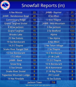
6 NW Moose… 23 inches.
Jackson Hole – Raymer… 21 inches.
Jackson Hole – Rendezvous Bowl… 20 inches.
Grand Targhee Snotel… 17 inches.
Jackson Hole – Mid Mountain… 17 inches.
Phillips Bench Snotel… 16 inches.
5 NW Jackson… 15.5 inches.
Grand Targhee – Chief Joseph… 15 inches.
Togwotee Pass Snotel… 13 inches.
2 NE Teton Village… 12 inches.
Grassy Lake Snotel… 12 inches.
3 SSW Wilson… 12 inches.
Snow King… 10 inches.
3 NNE Wilson… 10 inches.
Jackson Hole – Base… 10 inches.
Snake River Stn Snotel… 9 inches.
Granite Creek Snotel… 9 inches.
Togwotee Mountain Lodge… 8 inches.
Jackson… 7.6 inches.
Base Camp Snotel… 7 inches.
12 NE Jackson… 6.5 inches.
Gros Ventre Summit Snotel… 3 inches.
Washakie County…
Powder River Pass Snotel… 2 inches.
5 NNW Ten Sleep… 1 inch.
16 SSE Ten Sleep… 1 inch.
Ten Sleep… 0.4 inches.
Yellowstone National Park…
Snake River Ranger Station… 12 inches.
Parker Peak Snotel… 7 inches.
Lewis Lake Divide Snotel… 6 inches.
Two Ocean Plateau Snotel… 6 inches.
Canyon Snotel… 5 inches.
Yellowstone East Entrance… 5 inches.
Sylvan Road Snotel… 5 inches.
Tower Falls Ranger Station… 5 inches.
Lamar Ranger Station… 4.4 inches.
Sylvan Lake Snotel… 3 inches.
Thumb Divide Snotel… 3 inches.