Strong Cold Front Crosses Star Valley Wednesday Afternoon
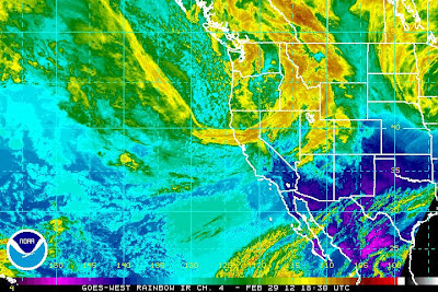
The next in a series of powerful upper level troughs of low pressure is moving eastward toward Star Valley this afternoon. This can be noted on the mid-day Water Vapor Satellite imagery
 |
||
| Mid day Water Vapor Imagery 2/29/12 |
This trough is driving a strong cold front toward Star Valley and at noon it was crossing the Snake River Valley near Pocatello and Idaho Falls.
The surface analysis shows the frontal location around 8am this morning, and at its’ present rate of motion will cross the Star Valley area between 2:30 and 4pm.

The front will be accompanied by strong, gusty winds up to 40 mph and a period of heavy snow. Temperatures will drop sharply from around freezing to near 20 degrees after its passage. The system is moving rapidly, therefore, the duration of heavy snowfall will be only a couple of hours. A quick 2-4 inches of snow could result with lighter amounts continuing through the night.
Travel will be affected due to reduced visibilities and snow packed roads once the front passes.