Pattern Change
The Numerical models are all in agreement that the upper high pressure that has been in control over Star Valley for several days is giving way to a trough of low pressure over the western states. This will lead to the potential of the first significant precipitation for Western Wyoming and Southeastern Idaho since May.
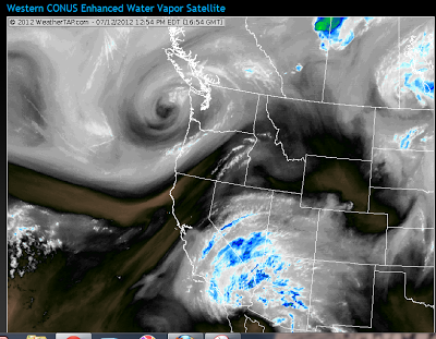
There are two important features that show up on the water vapor satellite imagery this Thursday morning.
 |
| Water Vapor Imagery Thursday AM 7/12/12 |
The pronounced low pressure circulation off the Pacific Northwest coast, which will lead to the trough over the western states. Of even more importance is the large area of moisture over the desert Southwest.
The precipitable water analysis for this same time shows the very moist monsoon air now moving northward into the deserts from Mexico.
 |
|
| Precipitable Water Thursday AM 7/12/12 |
Upwards of 2 inches has moved into the Lower Colorado River Valley,
By Saturday morning the trough of low pressure is located over the west with a southerly flow bringing the large amount of moisture northward across Star Valley.
 |
|
| 500 mb forecast Saturday an 7/14/12 |
The models are forecasting a large area of precipitation to spread northward across Star Valley in the form of showers and thundershowers.
 |
||||
| 48 hour forecasted rainfall through Sunday AM 7/15/12 |
As always with summer time precipitation their will be large variability as to how much any one location receives. But the pattern and available moisture suggests that the potential of substantial amounts are possible. Rainfall totals could range upwards to an inch in more favored locations.