Update on Approaching Pacific Storm to Western Wyoming-Heavy Snow in the Mountains
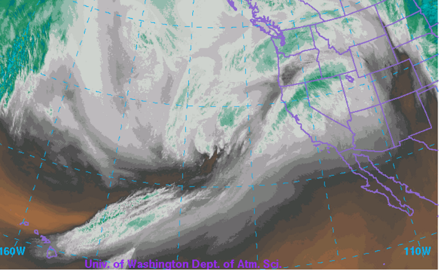
The latest significant Pacific storm is moving inland across California
and headed for Wyoming. The morning water vapor satellite imagery clearly
depicts the stream of very moist air mass originating near Hawaii which
will provide copious amounts of rain and mountain snows inland across
California northeastward into Western Wyoming.
 |
| Water Vapor Satellite Imagery Monday Morning |
Model forecast precipitation through Wednesday focus on the large totals in
Califonia and also in the mountains of Western Wyoming.
 |
| Model forecast precipitation from Monday morning through Wednesday evening. |
Snow levels will rise with the warmer air mass, with precipitation becoming mixed
snow/rain in Star Valley and likely mostly rain tonight and into Tuesday prior
to the arrival of colder air.
Following are the current statements and warning from Riverton Forecast Office.National Weather Service Riverton WY 315 AM MST Mon Feb 20 2017Star Valley- Including the cities of Afton, Alpine, Star Valley Ranch, and Thayne 357 AM MST Mon Feb 20 2017 Periods of snow are expected to develop across Star Valley this morning. Snow is expected to mix with or change to rain this afternoon into the evening. The precipitation is expected to change back to all snow Tuesday afternoon and evening as a cold front sweeps across western Wyoming. Rainfall amounts between a half and one inch are expected with this storm, with a few inches of wet snow possible. The rainfall along with some melting snow could result in localized flooding or ponding of water....A strong Pacific storm will bring heavy snow to the western mountains from this Afternoon through Tuesday night... .A strong Pacific storm will bring heavy snow to the western mountains from Monday afternoon through Tuesday evening. Also, strong west to southwest winds will cause significant blowing and drifting snow. The western valleys will see a mix of rain and snow. Teton and Gros Ventre Mountains-Salt River and Wyoming Ranges- 315 AM MST Mon Feb 20 2017 ...Winter Storm Warning in effect from noon today to 5 am MST Wednesday... The National Weather Service in Riverton has issued a Winter Storm Warning for snow and blowing snow, which is in effect from noon today to 5 AM MST Wednesday. The Winter Storm Watch is no longer in effect. * Timing...Snow and strong winds are expected to move into the western mountains of Wyoming Monday afternoon. Snow and wind are expected to continue through Tuesday night. * Snowfall Accumulation...12 to 24 inches are expected, with localized amounts up to 30 inches in the Teton mountains. * Wind and Visibility...West to southwest winds of 25 to 35 mph with gusts to 60 mph...especially in open areas or mountain summits. Visibility frequently below a quarter mile in heavy snow and blowing snow. * Main Impact...Travel will become very difficult with the wind and snow producing slick, snow-packed roads along with high drifts over mountain passes. Please monitor JHAVALANCHE.ORG if your plans include travel into the backcountry. Also, the severely reduced visibility will be very disorientating for those recreating in the backcountry.