National Weather Service Pocatello ID
232 PM MST Fri Feb 23 2018
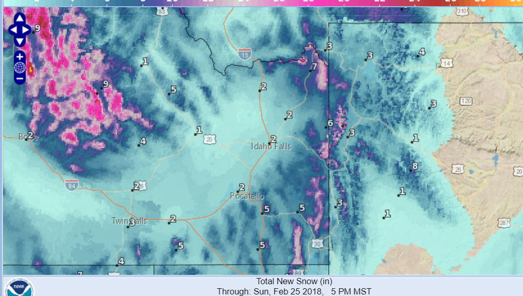
...Weekend Winter Storm Has Impact on Central and Eastern Idaho...
.A winter storm coming in from the Pacific Ocean will spread snow
and wind into central Idaho late tonight, and eastern Idaho during
the morning on Saturday. While snow accumulations will be light,
the strong wind that will accompany the surface cold front will
cause heavy drifting snow and reduced visibility in blowing snow.
Persons planning travel through central and eastern Idaho should
be prepared for winter driving conditions. Check road conditions
and plan extra time to complete your travel. Carry clothing and
emergency items appropriate for the time of year.
Upper Snake Highlands-Caribou Highlands-
Wasatch Mountains/Idaho Portion-
232 PM MST Fri Feb 23 2018
...WINTER WEATHER ADVISORY IN EFFECT FROM MIDNIGHT TONIGHT TO
6 AM MST SUNDAY ABOVE 6500 FEET...
* WHAT...Snow and blowing snow expected. Plan on slippery road
conditions. In addition, areas of poor visibility are expected.
Total snow accumulations of 3 to 6 inches, with localized
amounts up to 10 inches, are expected. Elevations below 6500
feet should expect 1 to 5 inches of snow.
* WHERE...Upper Snake Highlands, Caribou Highlands and Wasatch
Mountains/Idaho Portion Counties.
* WHEN...From midnight tonight to 6 AM MST Sunday.
* ADDITIONAL DETAILS...Winds gusting as high as 30 mph will
cause areas of blowing and drifting snow, especially over
mountain passes. Cold wind chills as low as 15 below zero will
cause frostbite in as little as 30 minutes to exposed skin.