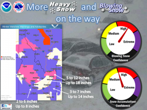
Next Snow Event on the Way for Western Wyoming and Southeast Idaho Tonight and Monday
National Weather Service Riverton WY
112 AM MST Sun Feb 25 2018

...MODERATE SNOW RETURNING TO PORTIONS OF WESTERN WYOMING...

.Mainly light snow will fall today. Periods of heavier snow will
return Sunday night into Monday. At this time, the heaviest snow
is expected from late Sunday night into Monday morning.

Jackson Hole-Star Valley-
Including the cities of Jackson, Afton, Alpine,
Star Valley Ranch, and Thayne
112 AM MST Sun Feb 25 2018

...WINTER WEATHER ADVISORY IN EFFECT FROM 5 PM THIS AFTERNOON TO
5 PM MST MONDAY...

* WHAT...Snow expected. Total snow accumulations of 3 to 5 inches
  are expected.

* WHERE...Jackson Hole and Star Valley.

* WHEN...From 5 PM this afternoon to 5 PM MST Monday.

* ADDITIONAL DETAILS...Plan on difficult travel conditions.
  Winds gusting as high as 30 mph will cause patchy blowing and
  drifting snow.

Southeast Idaho is expecting significant snowfall