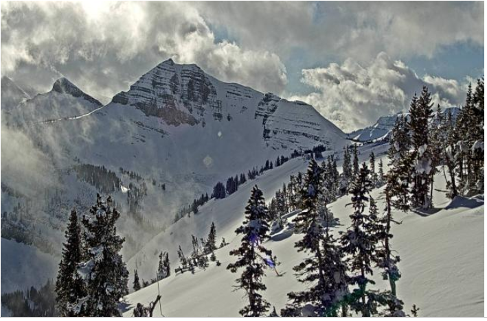
 Cody Bowl-Tetons
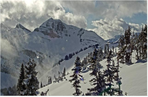
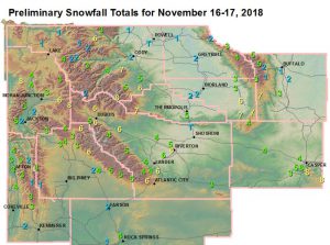
National Weather Service Riverton WY
0207 PM MST Sat Nov 17 2018


...Here is an updated report on Snowfall amounts around the area from
Friday afternoon through this morning.
Note: SnoTELS (Snow Telemetry) are remote sensing sites in high
mountain watersheds. Snowfall data from SNOTELS are estimated based
on snow water equivalent.

Location                              Snowfall

Big Horn County...
 Shell Creek Snotel...                4 inches.
 Bone Springs Divide Snotel...        2 inches.
 Greybull...                        1.7 inches.
 9 NNW Shell...                     1.6 inches.
 Bald Mountain Snotel...              1 inch.
 2 SSW Lovell...                    0.5 inches.

Fremont County...
 Deer Park Snotel...                  9 inches.
 9 SSE Lander...                      8 inches.
 9 NW Riverton...                     7 inches.
 Castle Creek Snotel...               7 inches.
 Brooks Lake...                       7 inches.
 9 SSE Lander...                    6.2 inches.
 South Pass Snotel...                 6 inches.
 4 W Riverton...                      6 inches.
 Dubois...                            6 inches.
 Burris...                            6 inches.
 2 W Riverton...                      6 inches.
 Lander...                          5.8 inches.
 Downtown Riverton                  5.7 inches.
 Hudson...                          5.5 inches.
 St. Lawrence Alt Snotel...           5 inches.
 Riverton Airport...                  5 inches.
 1 N Lander...                        5 inches.
 Burroughs Creek Snotel...            5 inches.
 Little Warm Snotel...                5 inches.
 Lander Airport...                  4.8 inches.
 Cold Springs Snotel...               4 inches.
 Townsend Creek Snotel...             4 inches.
 6 SW Lander...                     3.8 inches.
 7 WNW Lander...                    3.6 inches.
 Jeffrey City...                      3 inches.

Hot Springs County...
 Owl Creek Snotel...                  7 inches.
 Lucerne...                         4.8 inches.
 Thermopolis...                     4.5 inches.
 9 NE Thermopolis...                3.4 inches.
 Kirby...                           3.1 inches.

Johnson County...
 Bear Trap Meadow Snotel...           7 inches.
 Cloud Peak Reservoir Snotel...       5 inches.
 Little Goose Snotel...               5 inches.
 17 NNW Kaycee...                     3 inches.
 Soldier Park Snotel...               2 inches.
 13 SSE Buffalo...                    2 inches.
 Hansen Sawmill Snotel...             1 inch.
 4 SSW Buffalo...                     1 inch.

Lincoln County...
 Blind Bull Summit...                 4 inches.
 Blind Bull Summit Snotel...          4 inches.
 Star Valley Ranch...               3.5 inches.
 Salt River Summit Snotel...          3 inches.
 5 SSE Smoot...                       3 inches.
 Hams Fork Snotel...                  3 inches.
 Cottonwood Creek Snotel...           3 inches.
 Commissary Ridge...                  3 inches.
 Willow Creek Snotel...               3 inches.
 Afton...                           2.7 inches.
 2 SE Thayne...                     2.5 inches.
 Indian Creek Snotel...               2 inches.
 Box Y Ranch...                       2 inches.
 Spring Creek Divide Snotel...        1 inch.

Natrona County...
 Reno Hill Snotel...                  7 inches.
 Casper Mountain Snotel...            7 inches.
 5 SSW Casper...                    6.5 inches.
 1 S Casper...                      6.5 inches.
 4 WSW Casper...                    5.8 inches.
 Casper...                    3.5 - 5.5 inches.
 10 WSW Casper...                     5 inches.
 Casper Airport...                  4.2 inches.
 Powder River...                      4 inches.
 Casper Mountain...                   4 inches.
 Grave Springs Snotel...              4 inches.
 18 SW Casper...                      3 inches.

Park County...
 Kirwin Snotel...                     7 inches.
 3 NE Sunshine...                   6.2 inches.
 Marquette Snotel...                  6 inches.
 Timber Creek Snotel...               5 inches.
 5 WSW Meeteetse...                 4.5 inches.
 Wolverine Snotel...                  4 inches.
 26 SW Cody...                      3.8 inches.
 Beartooth Lake Snotel...             3 inches.
 Blackwater Snotel...                 2 inches.
 Evening Star Snotel...               2 inches.
 Younts Peak Snotel...                2 inches.
 Pahaska...                           2 inches.
 2 WSW Cody...                        2 inches.
 Cody...                            0.5 inches.
 3 NE Clark...                      0.5 inches.
 4 ENE Powell...                    0.3 inches.

Sublette County...
 Elkhart Park G.S. Snotel...          6 inches.
 Gunsite Pass Snotel...               6 inches.
 Pinedale...                          6 inches.
 Big Sandy Opening Snotel...          5 inches.
 Larsen Creek Snotel...               5 inches.
 Pocket Creek Snotel...               5 inches.
 Loomis Park Snotel...                4 inches.
 Kendall Ranger Station Snotel...     3 inches.
 East Rim Divide Snotel...            3 inches.
 New Fork Lake Snotel...              3 inches.
 Boulder Rearing Station...           2 inches.
 Triple Peak Snotel...                2 inches.
 Snider Basin Snotel...               1 inch.

Sweetwater County...
 Green River...                1 to 3.5 inches.
 Rock Springs...                    2.3 inches.
 2 NNE Farson...                      2 inches.

Teton County...
 Togwotee Pass Snotel...              8 inches.
 Grassy Lake Snotel...                8 inches.
 Togwotee Mountain Lodge...           6 inches.
 Phillips Bench Snotel...             5 inches.
 Grand Targhee - Chief Joseph...      5 inches.
 Gros Ventre Summit Snotel...         4 inches.
 Jackson Hole - Raymer...             4 inches.
 2 NE Teton Village...              3.3 inches.
 Jackson Hole - Rendezvous Bowl...    3 inches.
 Grand Targhee Snotel...              3 inches.
 Base Camp Snotel...                  3 inches.
 6 NW Moose...                        3 inches.
 Granite Creek Snotel...              3 inches.
 Moose...                           2.6 inches.
 5 NW Jackson...                    2.3 inches.
 Jackson Dam...                     2.1 inches.
 Snow King...                         2 inches.
 12 NE Jackson...                     2 inches.
 Jackson Hole - Mid Mountain...       2 inches.
 Snake River Stn Snotel...            1 inch.
 Jackson Hole - Base...               1 inch.

Washakie County...
 27 S Ten Sleep...                  7.1 inches.
 Middle Powder Snotel...              7 inches.
 16 SSE Ten Sleep...                  6 inches.
 Powder River Pass Snotel...          3 inches.
 5 NNW Ten Sleep...                 2.7 inches.
 Ten Sleep...                       2.5 inches.
 Winchester...                        2 inches.
 8 SW Worland...                      2 inches.

Yellowstone National Park...
 Lewis Lake Divide Snotel...          4 inches.
 Sylvan Lake Snotel...                4 inches.
 Two Ocean Plateau Snotel...          3 inches.
 Sylvan Road Snotel...                2 inches.
 Parker Peak Snotel...                1 inch.
 Lamar Ranger Station...              1 inch.
 Canyon Snotel...                     1 inch.
 Tower Falls Ranger Station...      0.2 inches.