
Snow to Visit Star Valley Thanksgiving Weekend
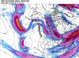
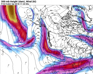
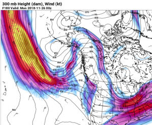
The current pleasant but cool weather will persist through the middle of this coming week. However the computer models are in agreement that by Thanksgiving Day our current high pressure will give way to storm systems moving from the Pacific across the Rocky Mountain states. This pattern change can best be seen in a series of 300 mb(30,000 ft) maps.
While this pattern change puts Star Valley and western Wyoming in line for snow later this week, there remains uncertainty as to timing and amount. It does appear that snow chances increase on Thanksgiving Day with the primary threat arriving on Friday and diminishing by Sunday.
An effective way of describing the uncertainty is with probabilities. Following are the forecasts of the chances of .25 water equivalent of snow(2-4 inches of actual snow) occurring as forecast by the National Weather Service beginning Thanksgiving Day.
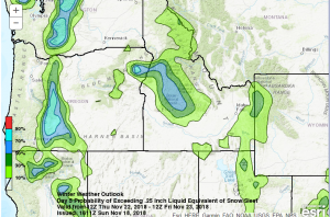
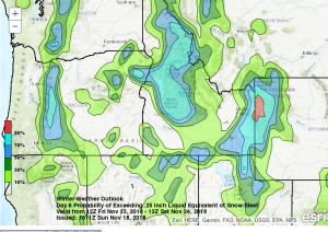
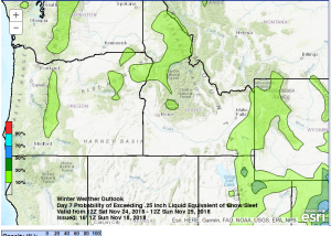
These graphics suggest that at this time Friday seems most likely snowy.
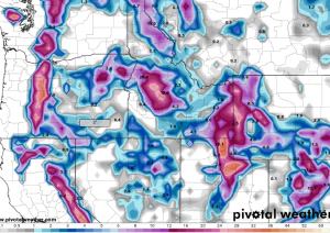
The model forecast of the total amount of snow occurring this coming week, generally toward the end of the week in Western Wyoming:
The computer models are steadily improving in accuracy, however predicting the amount and location of snowfall remains difficult particularly 4 or 5 days in advance. At this time there is certainly confidence in saying that weather will be favorable for Thanksgiving Weekend travel through Wednesday and then concern for winter weather traveling conditions begin on Thanksgiving Day and then substantially increase by Friday.