URGENT - WINTER WEATHER MESSAGE
National Weather Service Riverton WY
307 PM MST Sat Dec 29 2018
...Strong winter storm to bring snow, cold, and wind tonight into
Sunday...
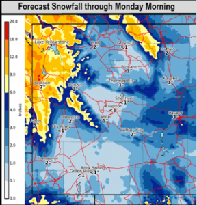
.A fast moving winter storm will bring cold temperatures,
snowfall, and strong wind to Wyoming later tonight into Sunday.
Strong wind ahead of the storm will start today, over the
Absarokas. Moderate to heavy snow will begin tonight in northwest
WY and spread to the southeast Sunday. Moderate to strong wind
will create hazardous travel conditions for much of the area. Very
cold temperatures will be over the area Monday night into
Tuesday.
Star Valley-Salt River and Wyoming Ranges-
Including the cities of Afton, Alpine, Star Valley Ranch, Thayne,
and Fossil Butte National Monument
307 PM MST Sat Dec 29 2018
...WINTER WEATHER ADVISORY IN EFFECT FROM MIDNIGHT TONIGHT TO
9 PM MST SUNDAY...
* WHAT...Snow expected. Total snow accumulations of 3 to 5 inches
in the valley, 4 to 8 inches in the mountains expected. Winds
gusting as high as 50 mph in the mountains.
* WHERE...Star Valley and Salt River and Wyoming Ranges.
* WHEN...From midnight tonight to 9 PM MST Sunday.
* ADDITIONAL DETAILS...Plan on slippery road conditions. Patchy
blowing snow could significantly reduce visibility. Gusty
winds could bring down tree branches.
PRECAUTIONARY/PREPAREDNESS ACTIONS...
A Winter Weather Advisory for snow means periods of snow will
cause primarily travel difficulties. Expect snow covered roads
and limited visibilities, and use caution while driving.
The latest road conditions for the state you are calling from can
be obtained by calling 5 1 1.