 Snowfall January 17-18 2019
National Weather Service Riverton WY
148 PM MST Fri Jan 18 2019
The following are snowfall amounts from 5 AM Thursday, January 17th
through 11 AM Friday, January 18th.
Observations are collected from a variety of sources with varying
equipment and exposures. We thank all volunteer weather observers
for their dedication. Not all data listed are considered official.
Note: SnoTELS (Snow Telemetry) are remote sensing sites in high
mountain watersheds. Snowfall data from SNOTELS are estimated based
on snow water equivalent.
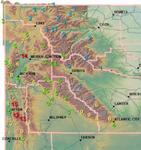
***** Snowfall Reports *****
Location Snowfall
Fremont County...
South Pass Snotel... 6 inches.
Deer Park Snotel... 6 inches.
Hobbs Park Snotel... 6 inches.
Atlantic City... 4 inches.
Brooks Lake... 4 inches.
Burroughs Creek Snotel... 2 inches.
Cold Springs Snotel... 1 inch.
Townsend Creek Snotel... 1 inch.
St. Lawrence Alt Snotel... 1 inch.
Hot Springs County...
Owl Creek Snotel... 1 inch.
Lincoln County...
Willow Creek Snotel... 15 inches.
Commissary Ridge... 13 inches.
3 SE Bedford... 12 inches.
Cottonwood Creek Snotel... 12 inches.
5 SSE Smoot... 11 inches.
Spring Creek Divide Snotel... 11 inches.
Star Valley Ranch... 9 inches.
Indian Creek Snotel... 9 inches.
2 SE Thayne... 8 inches.
Blind Bull Summit Snotel... 7 inches.
Salt River Summit Snotel... 7 inches.
Blind Bull Summit... 6 inches.
Box Y Ranch... 6 inches.
Kelley Ranger Station Snotel... 6 inches.
Afton... 5 inches.
Hams Fork Snotel... 5 inches.
Natrona County...
Reno Hill Snotel... 5 inches.
Casper Mountain Snotel... 5 inches.
4 WSW Casper... 2 inches.
Park County...
Younts Peak Snotel... 4 inches.
Blackwater Snotel... 2 inches.
Kirwin Snotel... 2 inches.
Marquette Snotel... 2 inches.
Evening Star Snotel... 1 inch.
Wolverine Snotel... 1 inch.
Pahaska... 1 inch.
Beartooth Lake Snotel... 1 inch.
Sublette County...
Pocket Creek Snotel... 9 inches.
Big Sandy Opening Snotel... 9 inches.
Larsen Creek Snotel... 8 inches.
Triple Peak Snotel... 7 inches.
Bondurant... 6 inches.
Snider Basin Snotel... 6 inches.
Loomis Park Snotel... 5 inches.
Gunsite Pass Snotel... 5 inches.
Kendall Ranger Station Snotel... 5 inches.
New Fork Lake Snotel... 5 inches.
East Rim Divide Snotel... 4 inches.
14 NW Pinedale... 4 inches.
Daniel Fish Hatchery... 3 inches.
Pinedale... 3 inches.
Boulder Rearing Station... 3 inches.
Elkhart Park G.S. Snotel... 3 inches.
Sweetwater County...
Buckboard Marina... 4.5 inches.
Green River... 4 to 3 inches.
Rock Springs... 2.5 inches.
Wamsutter... 1.5 inches.
Teton County...
Colter Bay... 14 inches.
Jackson Hole - Mid Mountain... 10 inches.
Jackson Hole - Raymer... 9 inches.
Phillips Bench Snotel... 9 inches.
Jackson Hole - Rendezvous Bowl... 9 inches.
2 NE Teton Village... 8 inches.
6 NW Moose... 8 inches.
Grand Targhee Snotel... 8 inches.
Grand Targhee - Chief Joseph... 7 inches.
Snake River Stn Snotel... 6 inches.
Granite Creek Snotel... 6 inches.
Base Camp Snotel... 6 inches.
3 SSW Wilson... 6 inches.
Jackson Hole - Base... 5 inches.
3 NNE Wilson... 5 inches.
Grassy Lake Snotel... 5 inches.
Gros Ventre Summit Snotel... 5 inches.
Darwin Ranch... 5 inches.
Snow King... 5 inches.
12 NE Jackson... 4 inches.
Grand Targhee Ski Area... 4 inches.
Togwotee Pass Snotel... 4 inches.
Togwotee Mountain Lodge... 3 inches.
1 NNW Alta... 3 inches.
Yellowstone National Park...
Lewis Lake Divide Snotel... 7 inches.
Thumb Divide Snotel... 5 inches.
Two Ocean Plateau Snotel... 3 inches.
Canyon Snotel... 2 inches.
Parker Peak Snotel... 2 inches.
Lamar Ranger Station... 1 inch.
Tower Falls Ranger Station... 1 inch.
Sylvan Lake Snotel... 1 inch.
Sylvan Road Snotel... 1 inch