National Weather Service Riverton WY
451 PM MST Sat Jan 19 2019
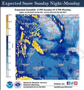
...Additional snow accumulations expected for Far Western Wyoming
Tonight...
...Significant snow possible across much of Central and Western
Wyoming for sunday night through Monday night...
.Another weather system will deliver yet more additional snowfall
to Far Western Wyoming tonight. Then a strong Pacific trough will
deliver accumulating snow to both sides of the Continental Divide
Sunday night through Monday night. Accumulations could be
significant with this next weather event.
Yellowstone National Park-Absaroka Mountains-Star Valley-
Salt River and Wyoming Ranges-
Including the cities of Lake, Mammoth, Old Faithful, Afton,
Alpine, Star Valley Ranch, and Thayne
451 PM MST Sat Jan 19 2019
...WINTER STORM WATCH IN EFFECT FROM SUNDAY AFTERNOON THROUGH
MONDAY AFTERNOON...
* WHAT...Heavy snow possible. Total snow accumulations of 3 to 9
inches possible. Winds could possibly gust as high as 40 mph on
the higher peaks.
* WHERE...Yellowstone National Park, Absaroka Mountains, Star
Valley, and the Salt River and Wyoming Ranges.
* WHEN...From Sunday afternoon through Monday afternoon.
* ADDITIONAL DETAILS...Travel could be very difficult. Areas of
blowing snow could significantly reduce visibility. The
hazardous conditions could impact the morning commute. Gusty
winds could bring down tree branches.
PRECAUTIONARY/PREPAREDNESS ACTIONS...
A Winter Storm Watch means there is potential for significant
snow, sleet or ice accumulations that may impact travel. Continue
to monitor the latest forecasts.