National Weather Service Riverton WY
1015 AM MDT Sun Oct 20 2019
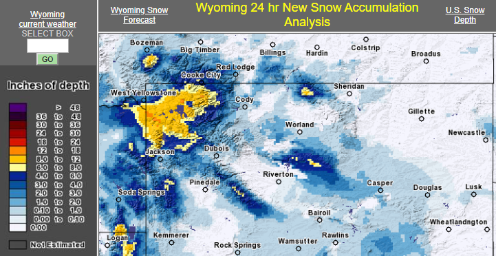
...PRELIMINARY SNOWFALL REPORTS...
Below are 24-hour snowfall reports through 9 AM Sunday.
Notes: Location of reports are referenced from city center.
Snowfall reports from SNOTEL (Snow Telemetry) sites are
estimated and based on snow water equivalent.
Location Amount Time/Date Elevation (ft.)
...Wyoming...
...Fremont County...
Dubois 0.5 in 0600 AM 10/20 6955
...Lincoln County...
Thayne 2SE 3.3 in 0700 AM 10/20 6086
Bedford 3SE 3.0 in 0600 AM 10/20 6345
Smoot 5 SSE 2.0 in 0700 AM 10/20 7005
Afton 1.3 in 0800 AM 10/20 6248
...Natrona County...
Powder River 2.0 in 0600 AM 10/20 5722
Casper 10 WSW 1.5 in 0700 AM 10/20 5277
CASPER 1SW 1.0 in 0745 AM 10/20 5143
Casper 11 WSW 1.0 in 0700 AM 10/20 5302
Casper 5 SSW 1.0 in 0700 AM 10/20 6262
Casper 4 WSW 0.8 in 0700 AM 10/20 5151
Casper 1S 0.5 in 0700 AM 10/20 5522
Casper Airport 0.3 in 0600 AM 10/20 5277
Casper 1 NW 0.3 in 0700 AM 10/20 5142
...Park County...
East Entrance - YNP 9.0 in 0600 AM 10/20 6954
Pahaska 8.0 in 0700 AM 10/20 6692
...Teton County...
Snake Rvr Ranger Station - Y 7.0 in 0800 AM 10/20 6882
Teton Village 2 NE 3.3 in 0700 AM 10/20 6339
Jackson 12 NE 1.5 in 0835 AM 10/20 6663
...Washakie County...
Ten Sleep 16SSE 1.0 in 0700 AM 10/20 4680
Ten Sleep 0.2 in 0700 AM 10/20 4426
Observations are collected from a variety of sources with varying
equipment and exposures. We thank all volunteer weather observers
for their dedication. Not all data listed are considered official.
SNOTEL Observations:
Location Snowfall
Big Horn County...
Bone Springs DivideSnotel... 6 inches.
Bald Mountain Snotel... 3 inches.
Shell CreekSnotel... 2 inches.
Fremont County...
Deer Park Snotel... 7 inches.
South Pass Snotel... 5 inches.
Brooks Lake... 4 inches.
Hobbs Park Snotel... 4 inches.
Burroughs CreekSnotel... 2 inches.
Little Warm Snotel... 2 inches.
St. Lawrence Alt Snotel... 1 inch.
Johnson County...
Little Goose Snotel... 6 inches.
Bear Trap Meadow Snotel... 3 inches.
Cloud Peak ReservoirSnotel... 3 inches.
Hansen Sawmill Snotel... 2 inches.
Soldier Park Snotel... 1 inch.
Lincoln County...
Commissary Ridge... 10 inches.
Willow CreekSnotel... 10 inches.
Indian CreekSnotel... 9 inches.
Spring CreekDivideSnotel... 8 inches.
Blind Bull Summit Snotel... 7 inches.
Blind Bull Summit... 6 inches.
Cottonwood CreekSnotel... 6 inches.
Box Y Ranch... 4 inches.
Salt River Summit Snotel... 3 inches.
Kelley Ranger Station Snotel... 3 inches.
Hams Fork Snotel... 2 inches.
Natrona County...
Grave Springs Snotel... 5 inches.
Reno Hill Snotel... 4 inches.
Casper Mountain Snotel... 4 inches.
Park County...
Beartooth Lake Snotel... 11 inches.
Evening Star Snotel... 8 inches.
Blackwater Snotel... 4 inches.
Younts Peak Snotel... 4 inches.
Kirwin Snotel... 3 inches.
Marquette Snotel... 1 inch.
Wolverine Snotel... 1 inch.
Sublette County...
Triple Peak Snotel... 8 inches.
Big Sandy Opening Snotel... 4 inches.
Snider BasinSnotel... 4 inches.
Gunsite Pass Snotel... 3 inches.
Loomis Park Snotel... 2 inches.
East Rim DivideSnotel... 2 inches.
Kendall Ranger Station Snotel... 2 inches.
Larsen CreekSnotel... 1 inch.
New Fork Lake Snotel... 1 inch.
Elkhart Park G.S. Snotel... 1 inch.
Teton County...
Jackson Hole - Rendezvous Bowl... 13 inches.
Jackson Hole - Raymer... 12 inches.
Jackson Hole - Mid Mountain... 11 inches.
Grassy Lake Snotel... 10 inches.
Grand Targhee - Chief Joseph... 10 inches.
Grand Targhee Snotel... 10 inches.
6 NW Moose... 10 inches.
Togwotee Pass Snotel... 8 inches.
Phillips Bench Snotel... 7 inches.
Snake River Stn Snotel... 6 inches.
Snow King... 5 inches.
Base Camp Snotel... 5 inches.
Togwotee Mountain Lodge... 4 inches.
Jackson Hole - Base... 3 inches.
Gros Ventre Summit Snotel... 2 inches.
Washakie County...
Powder River Pass Snotel... 5 inches.
Middle Powder Snotel... 4 inches.
Yellowstone National Park...
Lewis Lake DivideSnotel... 12 inches.
Parker Peak Snotel... 10 inches.
Canyon Snotel... 9 inches.
Thumb DivideSnotel... 8 inches.
Sylvan Lake Snotel... 7 inches.
Sylvan Road Snotel... 5 inches.