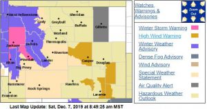
Winter Storm Warning Star Valley Saturday Night and Sunday
A winter storm warning has been issued for Star Valley tonight and Sunday as a weather system moves inland today and across the Northern and Central Rockies Sunday.
Water Vapor Loop through Saturday morning December 7 2019
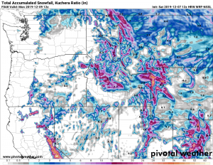
223 AM MST Sat Dec 7 2019

...Periods of Moderate to Heavy Snow to impact far western
Wyoming this afternoon through Sunday evening...

.Moisture from a Pacific storm will move over the far western
mountains by this afternoon. Snow will then spread southward over
the Star Valley, Hoback Junction and the Salt/Wyoming Ranges by
this evening. Periods of moderate to heavy snow will occur over
these areas tonight through Sunday and into early Sunday evening.
The snow will gradually taper off end Sunday evening, as a cold
front moves across the area.


Star Valley-Upper Green River Basin Foothills-
Including the cities of Afton, Alpine, Star Valley Ranch, Thayne,
and Pinedale
223 AM MST Sat Dec 7 2019

...WINTER STORM WARNING IN EFFECT FROM 3 PM THIS AFTERNOON TO
9 PM MST SUNDAY...

* WHAT...Heavy snow expected. Total snow accumulations of 6 to 8
  inches...with locally higher amounts around 10 inches expected
  near Hoback Junction.

* WHERE...Star Valley and Upper Green River Basin Foothills,
  including Bondurant and Hoback Junction.

* WHEN...From 3 PM this afternoon to 9 PM MST Sunday.

* IMPACTS...Travel could be very difficult, especially over Salt
  River Pass and Hoback Junction.

PRECAUTIONARY/PREPAREDNESS ACTIONS...

If you must travel, keep an extra flashlight, food, and water in
your vehicle in case of an emergency.

The latest road conditions for the state you are calling from can
be obtained by calling 5 1 1.

Following is the model forecast of total snowfall through the weekend ending Monday morning.