Big Changes this Weekend Continuing into Next Week
 |
|
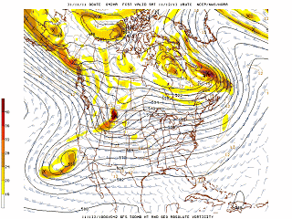
| 500 MB Noon Saturday 11/12/2011 |
After one more day on Friday of cool but pleasant weather, a fast moving storm will sweep across Star Valley Saturday morning. This system is a spin off from the massive storm that slammed Western Alaska Wednesday. It was one of most powerful storms in that part of Alaska in the past 40 years. The system which will move from the Gulf of Alaska southeastward into the Pacific Northwest early Friday will bring a strong cold front across the southeastern Idaho/western Wyoming area Saturday morning.
Snow levels will quickly drop to the valley floor Saturday morning with heavy snow for a couple hours with and just behind the front. The strong westerly flow will lead to the greatest snowfall along the north-south mountain ranges including the Salt and Tetons. Snowfall amounts will be greatest north of the Snake River with 4-8 inches in the mountains. It appears that 2-4 inches will be possible across Star Valley. Gusty winds will accompany the front and combined with the snow could lead to adverse traveling conditions, particularly across Teton Pass.
While the storm system will be moving quickly to east of the Valley by Saturday afternoon, a strong west to north flow will support an extended period of extensive cloud cover and periods of snow. By the middle of next week substantial amounts of snow could have accumulated in the mountains. and possibly in Star Valley as well.