Lapse Rates and Star Valley Clouds
During the summer months, the predominant cloud type over Star Valley and much of the intermountain west is cumuloform. Heating of the high elevation surfaces common across this area with any available moisture leads to cumulus and cumulonimbus on most afternoons. On some days the cumulus remain rather benign while other times they build dramatically into cumulonimbus and thunderstorms. The primary discriminatory parameter as to whether cumulus will develop into thunderstorms, given sufficient moisture, is the lapse rates of the surrounding environment. Following is a good discussion about lapse rates and the role it plays in atmospheric instability in support of cumulus clouds
Stability of Air
Adiabatic temperature change is an important factor in determining the stability of the air. We can think of air stability as the tendency for air to rise or fall through the atmosphere under its own “power”. Stable air has a tendency to resist movement. On the other hand, unstable air will easily rise. What gives air “power” to rise? The tendency for air to rise or fall depends on the adiabatic and environmental lapse rates.
Stable air
Stable Atmospheric Conditions
Stable atmospheric conditions prevail when the environmental lapse rate is less than the saturated adiabatic rate. At the surface (0 meters) both the parcel of air (red line) and the air of the surrounding environment (blue line) have the same temperature. The surrounding air is changing its temperature at a rate of .65oC/100 meters. The parcel on this day is “dry” and will rise and cool at a temperature of 1oC/100 meters. After giving the parcel a slight upward push, it rises to a level of 1000 meters where it cools to a temperature of 20oC. A measurement of the air surrounding the parcel shows a temperature of 23.5oC. In other words, the parcel is colder (and more dense) than the surrounding air at 1000 meters. If the uplift mechanism ceased, the parcel of air would return to the surface.
 Unstable Atmospheric Conditions
Unstable air
Air is unstable when the environmental lapse rate is greater than the dry adiabatic rate. Under these conditions, a rising parcel of air is warmer and less dense than the air surrounding it at any given elevation. Follow up the graph for the rising parcel of air. Note that at any elevation above the surface the parcel temperature is higher than the air that surrounds it. Even as it reaches the dew point temperature at 2000 meters, the air remains warmer than the surrounding air. As a result it continues to rise and cool at the saturated adiabatic rate. Vertically developed clouds are likely to develop under unstable conditions such as this.

 Unstable Atmospheric Conditions
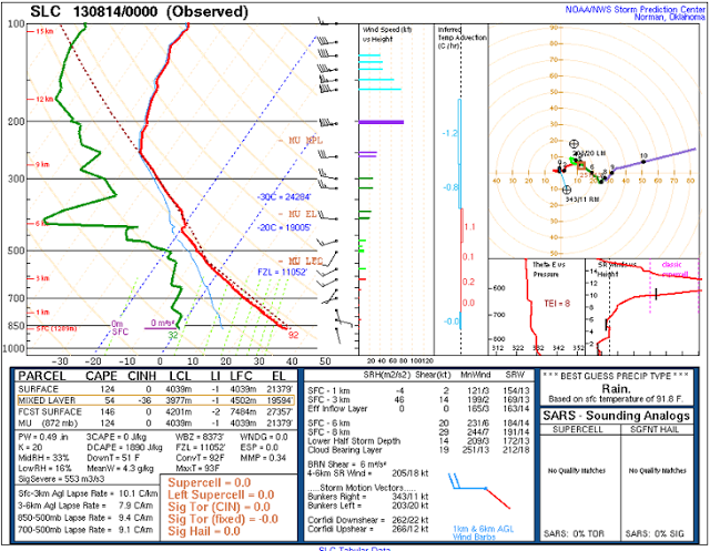
On August 13 2013, the environmental lapse rates were near dry adiabatic over Star Valley during the day as shown on the nearest upper air evening sounding at Salt Lake City. This was likely typical of the air mass over Star Valley, even though no upper air observation was available.
The sfc-3KM lapse rates is near 10C/km and above 9C/km up to 500mb.
Following is a video taken from the Star Valley Ranch web cam showing the very rapid development of cumulus and then cumulonimbus.
Once the cumulus form, they very quickly grow vertically in the steep lapse rate environment,
Just looking at a two hour period in the early afternoon from both the Star Valley Ranch web cam looking west and the webcam pointed north, clouds grow from inception to full blown cumulonimbus in less than two hours.
