URGENT - WINTER WEATHER MESSAGE
National Weather Service Riverton WY
1116 AM MST Fri Feb 22 2019

...Winter Storms will likely impact Western Wyoming Saturday
night through Tuesday...

.Significant snow and blowing snow are likely across much of
western Wyoming Saturday night through Tuesday. Snow is expected
begin Saturday morning, however, the heaviest snowfall will
arrive Saturday night. This snow could combine with very strong
winds, which could produce considerable blowing and drifting snow,
very poor visibility, and cold wind chills.


Jackson Hole-Star Valley-
Including the cities of Jackson, Afton, Alpine,
Star Valley Ranch, and Thayne
1116 AM MST Fri Feb 22 2019

...WINTER STORM WATCH IN EFFECT FROM SATURDAY EVENING THROUGH
TUESDAY AFTERNOON...

* WHAT...Heavy snow possible. Saturday snow accumulations of 2 to
  4 inches possible with most of the accumulation occurring
  Saturday night. Sunday snow accumulations of 4 to 7 inches
  possible. Total snow accumulations through Tuesday could be as
  much as 1 to 2 feet.

* WHERE...Jackson Hole and Star Valley.
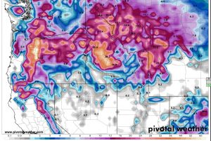
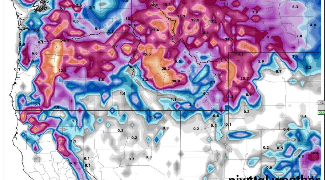
Total Model Snowfall Forecast through Tuesday Morning
* WHEN...From Saturday evening through Tuesday afternoon.

* ADDITIONAL DETAILS...Travel could be very difficult to
  impossible. The hazardous conditions could impact the morning
  and evening commute.

PRECAUTIONARY/PREPAREDNESS ACTIONS...

A Winter Storm Watch means there is potential for significant
snow, sleet or ice accumulations that may impact travel. Continue
to monitor the latest forecasts.
URGENT - WINTER WEATHER MESSAGE National Weather Service Riverton WY 1116 AM MST Fri Feb 22 2019 ...Winter Storms will likely impact Western Wyoming Saturday night through Tuesday... .Significant snow and blowing snow are likely across much of western Wyoming Saturday night through Tuesday. Snow is expected begin Saturday morning, however, the heaviest snowfall will arrive Saturday night. This snow could combine with very strong winds, which could produce considerable blowing and drifting snow, very poor visibility, and cold wind chills. Jackson Hole-Star Valley- Including the cities of Jackson, Afton, Alpine, Star Valley Ranch, and Thayne 1116 AM MST Fri Feb 22 2019 ...WINTER STORM WATCH IN EFFECT FROM SATURDAY EVENING THROUGH TUESDAY AFTERNOON... * WHAT...Heavy snow possible. Saturday snow accumulations of 2 to 4 inches possible with most of the accumulation occurring Saturday night. Sunday snow accumulations of 4 to 7 inches possible. Total snow accumulations through Tuesday could be as much as 1 to 2 feet. * WHERE...Jackson Hole and Star Valley.