National Weather Service Riverton WY
1236 PM MST Fri Feb 16 2018
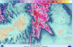
...Major winter storm is in the offing for much of Western Wyoming
later Saturday through Sunday...
.Light snow will continue into Saturday morning across the
northwest mountains and Jackson Valley and then spread south into
the Star Valley, Upper Green River Basin Foothills and surrounding
mountains by Saturday evening. Snow may then be heavy at times
through Sunday afternoon.
Star Valley-
Including the cities of Afton, Alpine, Star Valley Ranch,
and Thayne
1236 PM MST Fri Feb 16 2018
...WINTER STORM WATCH IN EFFECT FROM SATURDAY AFTERNOON THROUGH
SUNDAY AFTERNOON...
* WHAT...Heavy snow possible. Total snow accumulations of 5 to 8
inches, with localized amounts up to 10 inches, are possible.
* WHERE...Star Valley.
* WHEN...From Saturday afternoon through Sunday afternoon.
********************************************************************
Yellowstone National Park-Absaroka Mountains-
Teton and Gros Ventre Mountains-Jackson Hole-
Including the cities of Lake, Mammoth, Old Faithful, and Jackson
1236 PM MST Fri Feb 16 2018

...WINTER STORM WATCH REMAINS IN EFFECT FROM SATURDAY AFTERNOON
THROUGH SUNDAY AFTERNOON...

* WHAT...Periods of moderate to heavy snow possible. Total snow
  accumulations of 1 to 2 feet in the Tetons/southwest
  Yellowstone, 10 to 16 inches in the mountains, and 7 to 11
  inches in the lower elevations, are possible.

* WHERE...Yellowstone National Park, Absaroka Mountains, Teton
  and Gros Ventre Mountains and Jackson Hole.

* WHEN...From Saturday afternoon through Sunday afternoon.

* ADDITIONAL DETAILS...Plan on difficult travel conditions. Tree
  branches could fall. Winds gusting as high as 50 mph could
  cause areas of blowing and drifting snow.

PRECAUTIONARY/PREPAREDNESS ACTIONS...

A Winter Storm Watch means there is potential for significant
snow, sleet or ice accumulations that may impact travel. Continue
to monitor the latest forecasts.