National Weather Service Riverton WY
259 AM MST Sat Feb 17 2018

...Major winter storm is in the offing for much of Western
Wyoming today through Sunday...

.Light snow will continue this morning across the northwest
mountains and Jackson Valley and then spread south into the Star
Valley, Upper Green River Basin Foothills and surrounding
mountains by this evening. Snow may then be heavy at times
through Sunday afternoon.


Star Valley-
Including the cities of Afton, Alpine, Star Valley Ranch,
and Thayne
259 AM MST Sat Feb 17 2018

...WINTER STORM WATCH REMAINS IN EFFECT FROM THIS AFTERNOON
THROUGH SUNDAY AFTERNOON...

* WHAT...Heavy snow possible. Total snow accumulations of 8 to 12
  inches are possible.

* WHERE...Star Valley.

* WHEN...From this afternoon through Sunday afternoon.

* ADDITIONAL DETAILS...Plan on difficult travel conditions.
  Winds gusting as high as 30 mph could cause patchy blowing and
  drifting snow.
National Weather Service Pocatello ID
214 AM MST Sat Feb 17 2018

...First Major Winter Storm for the New Year in Eastern Idaho...

.A moisture-laden storm should arrive early Saturday morning,
bringing heavy snow to elevations above 7000ft, and moderate snow
above 6000ft. Even the Snake River plain will see at least some
light to moderate snow, up to 3 inches or so in some locations.
The storm will also possibly generate strong southwest to west
wind of 25 to 35 mph. Winds of this power will drift and blow
snow, making road clearing operations difficult at best, with
temporary road closures possible. Travel will be hazardous with
slippery roads and reduced visiblities in blowing snow, if
traveling the high elevation highways and passes.


Caribou Highlands-Wasatch Mountains/Idaho Portion-
Including the cities of Henry, Soda Springs, and Montpelier
214 AM MST Sat Feb 17 2018

...WINTER STORM WARNING IN EFFECT FROM 2 PM THIS AFTERNOON TO
11 AM MST SUNDAY...

* WHAT...Heavy snow and blowing snow expected. Plan on difficult
  travel conditions. Tree branches could fall as well. Total
  snow accumulations of 6 to 9 inches, with localized amounts up
  to 14 inches, are expected.

* WHERE...The Bear River Range of mountains and the Caribou
  highlands.

* WHEN...From 2 PM this afternoon to 11 AM MST Sunday.

* ADDITIONAL DETAILS...Winds gusting as high as 50 mph will
  cause widespread blowing and drifting snow, especially over
  mountain passes.

PRECAUTIONARY/PREPAREDNESS ACTIONS...

A Winter Storm Warning for snow and blowing snow means severe
winter weather conditions are expected. If you must travel, keep
an extra flashlight, food and water in your vehicle in case of an
emergency. The latest road conditions can be obtained by calling
5 1 1.
...Major winter storm is in the offing for much of Western
Wyoming today through Sunday...
.Light snow will continue this morning across the northwest
mountains and Jackson Valley and then spread south into the Star
Valley, Upper Green River Basin Foothills and surrounding
mountains by this evening. Snow may then be heavy at times
through Sunday afternoon.
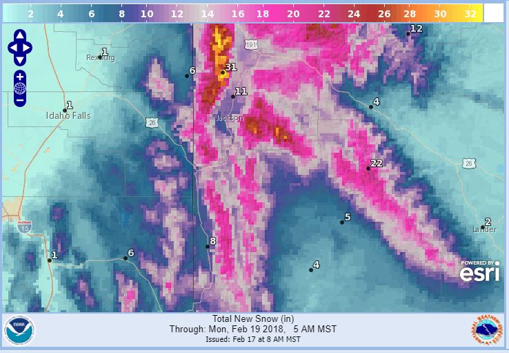
Teton and Gros Ventre Mountains-
259 AM MST Sat Feb 17 2018
...WINTER STORM WARNING IN EFFECT FROM NOON TODAY TO 5 PM MST
SUNDAY...
* WHAT...Heavy snow and blowing snow expected. Total snow
accumulations of 16 to 24 inches, with localized amounts up to
30 inches, are expected.
* WHERE...Teton and Gros Ventre Mountains.
* WHEN...From noon today to 5 PM MST Sunday.
* ADDITIONAL DETAILS...Travel will be very difficult, especially
over Teton Pass. Winds gusting as high as 55 mph will cause
widespread blowing and drifting snow. Please monitor
JHAVALANCHE.ORG if your plans include travel into the back
country.
PRECAUTIONARY/PREPAREDNESS ACTIONS...