Wet May Weather Continues across Western Wyoming and Star Valley
It has been a very wet May across most of Wyoming so far.
For Star Valley will use the record from Star Valley Ranch as an example. Through the 25th of the month the Star Valley Ranch station has measured 4.42 inches of precipitation There has been measurable precipitation at the station for 13 consecutive days through this Saturday. It has also been unseasonably cool much of the time. This is illustrated by the fact that there has been at least a trace of snow or hail on the last 9 days through Saturday. It now appears that the last week in May will be not much different as low pressure systems continue to move across the west with periods of showers and possible thundershowers. Snow will continue to be common in the higher mountains with still a potential for a few flurries in the valleys such as Star Valley.
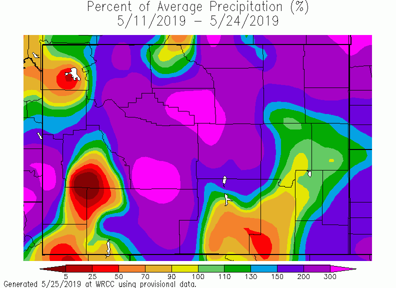
Looking at the departure from normal for precipitation for the past two weeks:
While there are a few drier locations such as Yellowstone NP, precipitation across all of Star Valley has been 200 to 300 percent of normal.
Following is a list of precipitation reports for the 4 days ending this last Thursday night across much of western and central Wyoming.
NATIONAL WEATHER SERVICE RIVERTON WY
1052 PM MDT Fri May 24 2019

Here are some selected 4 day rainfall amounts
across Western and Central Wyoming from Sunday
night through Thursday night.

Location                             Rainfall

Big Horn County...
 5 ENE Hyattville...               1.65 Inches.
 9 ENE Greybull...                 0.85 Inch.
 Greybull Airport...               0.83 Inch.
 2 SSW Lovell...                   0.71 Inch.
 Lovell...                         0.67 Inch.

Fremont County...
 6 SW Lander...                    3.72 Inches.
 Lander Airport...                 3.00 Inches.
 9 SSE Lander...                   2.95 Inches.
 7 WNW Lander...                   2.78 Inches.
 Sweetwater Station...             2.57 Inches.
 9 SSE Lander...                   2.53 Inches.
 1 N Lander...                     2.48 Inches.
 Boysen Dam...                     2.33 Inches.
 Riverton Airport...               1.79 Inches.
 Riverton...                       1.78 Inches.
 Kinnear...                        1.71 Inches.
 Fort Washakie...                  1.63 Inches.
 Pavillion...                      1.59 Inches.
 3 NNW Hudson...                   1.58 Inches.
 Riverton...                       1.58 Inches.
 Riverton Airport...               1.47 Inches.
 Shoshoni...                       1.42 Inches.
 7 SW Muddy Gap...                 1.36 Inches.
 10 W Fort Washakie...             1.23 Inches.
 Crowheart...                      1.22 Inches.
 Jeffrey City...                   1.06 Inches.

Hot Springs County...
 8 WNW Thermopolis...              2.55 Inches.
 Kirby...                          1.63 Inches.
 11 WNW Thermopolis...             1.58 Inches.
 9 NE Thermopolis...               1.44 Inches.
 Lucerne...                        1.29 Inches.
 10 S Meeteetse...                 0.78 Inch.

Johnson County...
 13 SSE Buffalo...                 1.58 Inches.
 17 NNW Kaycee...                  1.57 Inches.
 Buffalo...                        1.31 Inches.
 Buffalo Airport...                1.15 Inches.
 17 E Kaycee...                    1.14 Inches.

Lincoln County...
 2 SE Thayne...                    1.67 Inches.
 3 SE Bedford...                   1.45 Inches.
 Star Valley Ranch...              1.42 Inches.
 5 NNE Thayne...                   1.34 Inches.

Natrona County...
 5 SSW Casper...                   1.94 Inches.
 Casper...                         1.86 Inches.
 1 S Casper...                     1.72 Inches.
 11 WSW Casper...                  1.71 Inches.
 4 WSW Casper...                   1.60 Inches.
 10 WSW Casper...                  1.55 Inches.
 Powder River...                   1.40 Inches.
 18 SW Casper...                   1.27 Inches.
 Casper Airport...                 1.17 Inches.
 16 S Hiland...                    1.04 Inches.
 Midwest...                        0.99 Inch.
 12 NE Lysite...                   0.96 Inch.

Park County...
 Meeteetse...                      1.40 Inches.
 7 SW Cody...                      1.03 Inches.
 6 NE Cody...                      0.87 Inch.
 4 SW Powell...                    0.82 Inch.
 Cody Airport...                   0.64 Inch.
 4 ENE Powell...                   0.59 Inch.
 Powell...                         0.59 Inch.

Sublette County...
 14 NW Pinedale...                 1.11 Inches.

Sweetwater County...
  Station...                       2.57 Inches.

Washakie County...
 2 NE Worland...                   1.50 Inches.
 8 SW Worland...                   1.43 Inches.
 16 SSE Ten Sleep...               1.42 Inches.
 27 S Ten Sleep...                 1.39 Inches.
 Worland Airport...                1.36 Inches.
 5 NNW Ten Sleep...                1.32 Inches.
 15 SSW Big Trails...              0.86 Inch.
 12 ENE Ten Sleep...               0.80 Inch.